Download pdf of this post
The entire controversy over draining Van Norden Lake and wetlands is based on the contention that the Van Norden dam has been classified a “significant hazard” and as such the US Forest Service refuses to buy the land with the dam on it. We contend that it is in fact the Yuba River that poses the significant flood hazard as shown by hydraulic evaluation and that the Van Norden Dam provides significant hazard prevention through potential flood control.
The Forest Service definition of significant hazard is defined on page 13 of the Forest Service Manual FSM 7500 as
Significant. A classification that includes dams whose failure, malfunction, or misoperation would result in no probable loss of human life but could cause economic loss, disruption of lifeline facilities, or other significant impacts and would result in non-recoverable environmental damage.
To be clear, threat to loss of life is not the issue with this classification. The hazard is to economic loss, lifeline facilities and environmental damage. Furthermore, this classification has nothing to with the reliability of the dam or the probability that it will fail, which is very low.
In light of the fact that the Forest Service is trying to force the Truckee Donner Land Trust to drain the lake and wetlands based on this classification, the crucial question is how was it derived. The answer has been a bit of a mystery for us until this week. We knew that it was the result of a hydraulic evaluation by the company Balance Hydrologics, but the report was never released to the public. Fortunately we live in a country where our government keeps tabs on things like public safety and makes that information available to the public. The California Department of Safety of Dams (DSOD) keeps a public record of all documents concerning all of our dams, including Van Norden Dam. On a visit to their Sacramento office this week, we found the Balance Hydrologics report which we have put online for public scrutiny.
We urge everyone to take a look at the report. This is a pretty technical report so don’t be put off by the first 6 pages that use the technical jargon of the hydrology field. Suffice it to say that for the most part, Balance Hydrologics is using standard practices to perform the analysis. There is one parameter that is very important to the analysis that should be noted.The Breach Formation Time on page 5 was determined to be 1 hour. This means that we are not talking about a sudden failure that releases a wall of water down the Yuba.
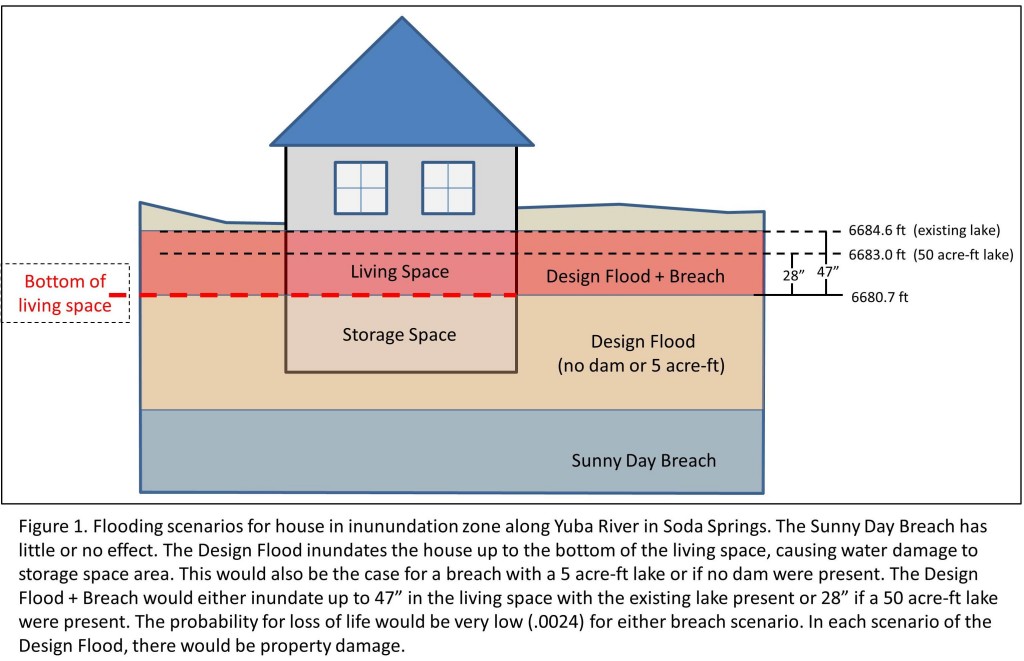
The crux of the report starts with the RESULTS section on page 7. The first section, the Sunny Day Breach, makes it clear that while it would be an event to see, the banks of the Yuba would contain the added flow from a breach under normal conditions. The real question of course is what happens if the breach were to occur during a storm. That scenario is covered by the Design Flood scenario. This quickly gets complicated, but the results can be visualized in Figure 1.
The important results of the scenario are
- The design flood was theoretically designed to be at the “tipping point” in which the level of the Yuba would be at the bottom of the living quarters for the only 2 houses in the inundation zone of the flood. This 1 in 120 year event was to measure the added contribution of a breach. There will still be property damage to the lower non-living sections of the homes at this level.
- The added contribution of a breach for the existing 190 acre-ft lake raised the level of the water in the living quarters by 47 inches over the one hour breach time. There would still be property damage to the home.
- Under conditions in which the lake contained only 50 acre-ft, the level only rose 28 inches. There would still be property damage.
- Under conditions in which the lake only contained 5 acre-ft (the level acceptable to the Forest Service), the level only rose 1 inch into living quarter. However, there would still be property damage.
The most important part of the report of course is the evaluation of the hazard posed to loss of life in this scenario. The crucial finding from the detailed discussion in the report is that they find there are only two homes in the vicinity of the dam that are affected and there is only a very low probability of .0024 for loss of life under this severe scenario. Just to put this into perspective, this means that in 1 out of every 420 storm events of this magnitude there was the probability of 1 loss of life. Given the fact that this storm event occurs only once in 120 years, this means that there is a probability of one loss of life every 50,400 years (420 x 120 years). Remember that this probability is only in the equally improbable event that the dam were to breach in the first place. The report takes a swing at estimating that risk and comes up with a range over two orders of magnitude. The upper value of the range would be 1 in 50,000 (you would be 6x more likely to die in a plane crash). The bottom value of the range is 1 in 5 million (you would be 12x more likely to be struck by lightning).
The bottom line is there is no added hazard to loss of life.
And yet the Forest Service claims that the report supports a classification of “significant hazard”. They base that claim on the fact that despite the improbability of loss of life there will still be property damage and lifeline disruption. And this is where the analysis falls apart. If you examine each scenario involving the design flood, there will be property damage, either to non-living or living quarters, and lifeline disruption through flooding of Soda Springs Road. Extending the logic used by the Forest Service this would mean that there would be a significant hazard from any flood scenario described including the presence of only 5 acre-ft of water. In fact, even if the dam were removed completely there would be significant hazard.
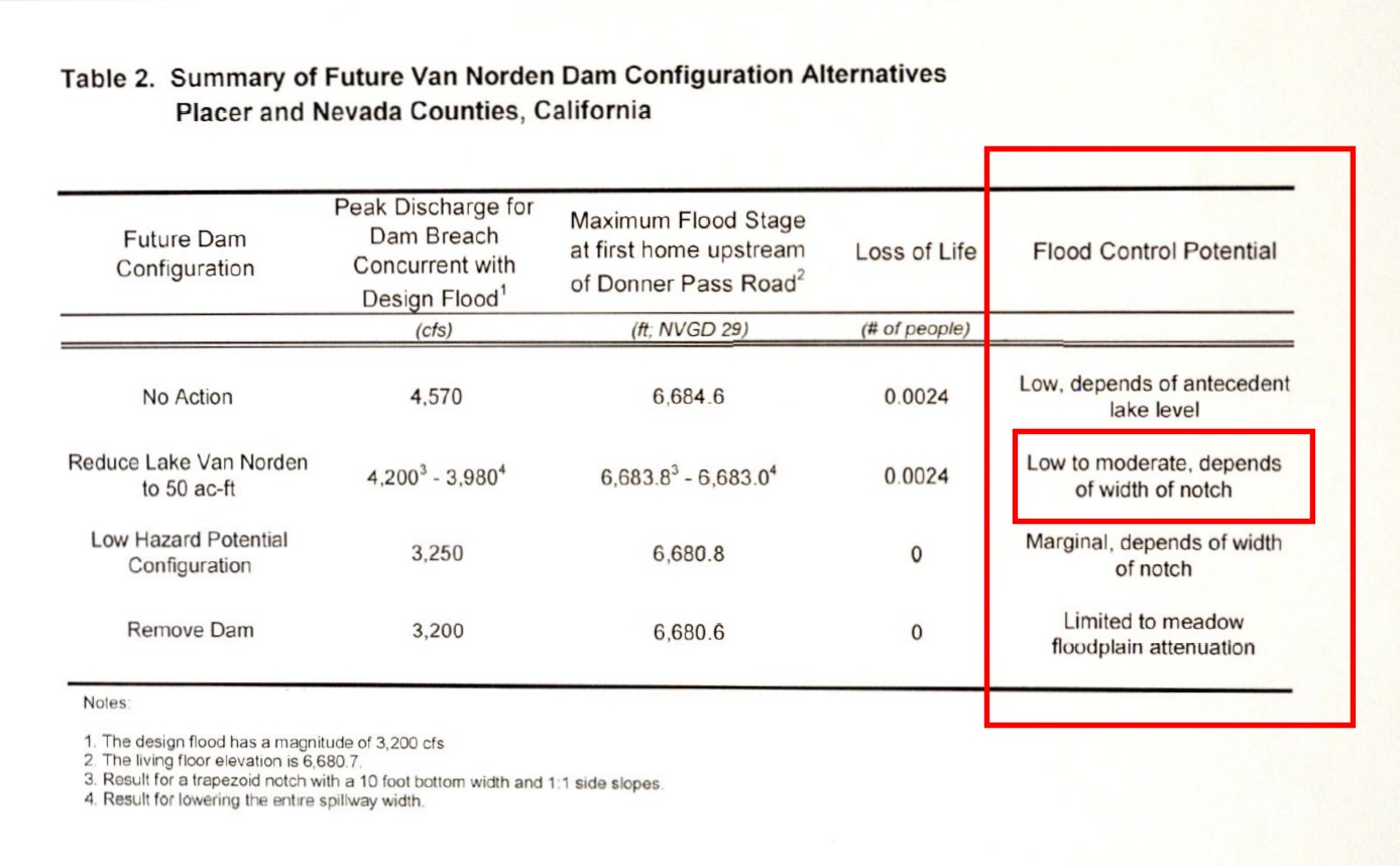
And that is point of this article. The Yuba river floods periodically, and when it does it poses a significant flood hazard. What this report touches on but fails to stress is that the Van Norden dam provides significant hazard prevention in the form of flood control. As shown in the last column of Table 2 of the report, the dam provides flood control potential except in the cases of reducing the lake to 5 acre-ft or removing the dam completely. And as the report clearly states, if the lake is left at 50 acre-ft it can provide moderate flood control that will serve to mitigate rather than increase the hazard of downstream flooding. The flood control effects are not seen in this type of report because the effects occur upstream of the dam. Attenuation of the storm surge by the dam would mean that in order to attain the flow rates for the Design Flood described here, the severity of the storm would have to be higher (something that would occur even less often), or in more practical terms, the same severity storm would cause less damage due to surge attenuation.
If public safety were really the issue for the Forest Service accepting Van Norden Dam then it would seem prudent for them to accept the dam. In fact they would be performing a public service by providing a form of flood control for the Summit Valley. The fact that they continue to oppose the dam in spite of the positive benefits to public safety and also the environmental benefits of preserving bio-diverse lake and wetland habitat in the valley makes one wonder what is their real motivation for their opposition to the dam? This is a question we think everyone should be asking the Forest Service.


One Response to The “Report” – If you don’t read anything else, READ THIS