Scientific Evidence that Draining Van Norden Lake Destroys the Wetlands

There have been plenty of unfounded statements by the Truckee Donner Land Trust and their supporters that draining Van Norden Lake will not affect the existing wetlands in the Donner Summit Valley. It of course makes no sense that removing millions of gallons of water stored in the lake would not have significant effects on the vegetation in the surrounding wetlands. The Land Trust claims that the “scientific” data will support their counter intuitive claims.

So let’s take a look at some real scientific data.

Now that we have seen the arid conditions in the Donner Summit Valley with the lake drained, it is possible to actually analyze data from the LandSat satellites that measures the vegetation in the Summit Valley. Scientists commonly use what’s called the NDVI (Normalized Difference Vegetation Index) to measure the volume of live green vegetation in an area. The data comes from satellites that measure the reflectance of light in the photosynthetically active radiation spectral region, 400-700 nm. The NDVI is an index value that quantitates the amount of vegetation using the reflectance measurements.

Thanks to the internet, anyone can get access to the LandSat data these days. Moreover, thanks to the scientists at ClimateEngine.Org that have made the ClimateEngine website available to everyone, it is now possible to visualize the NDVI data for the Donner Summit Valley. I would like to thank Dr. Benjamin Hatchett from the Division of Atmospheric Sciences at UNR for pointing me to this wonderful website. We would urge anyone that is interested to visit their site and run the engine analyses for themselves.

The ClimateEngine allows one to ask many questions about the vegetation data. It enabled us to ask the very specific question of “What was the effect of draining the lake on the surrounding wetland vegetation” and get a clear visual answer. We chose to look at the vegetation data for the month of August in 2016. This was the first full month in which Van Norden Lake was completely drained. In Figure 1 the Google map of the area shows the Donner Summit Valley with the drained lake. The ClimateEngine made it very easy to see just how the NDVI had changed by only looking at the percent of change from the average values over the period of 1982-2016. Using this criteria eliminates any natural seasonal decreases and ony looks at the differences due to draining the lake.

climate-engine-analysis-figure1-8-16

Those values are shown in Figure 2. The data clearly show that the vegetation decreased significantly for the wetland vegetation surrounding the dry lakebed. This is of course not surprising considering that the water essential for growth had been removed.

climate-engine-analysis-figure2-8-16

One might notice that the dry lake bed area actually looks like there has been a significant increase in vegetation. I’m sure the Land Trust would point to this as supporting their arguments. However, the strong green color in the lakebed is an artifact of the fact that during the 1982-2015 period there was water in the lake. Open water has a very low reflectance in the PAR range in comparison to the dry lakebed that is measured in 2016. As shown in Figure 3, the values for NDVI are very low in 2016, but still higher that when water was present. Since we are only looking at percent difference in Figure2, the green color in the lakebed is really an artifact of comparing very small values.

climate-engine-analysis-figure3-8-16

The take home info from this analysis of the data is that contrary to what supporters of draining the lake have claimed, the removal of Van Norden Lake will in fact reduce wetland vegetation just as common sense would predict. It should also be noted that in 2016, Van Nordon Lake was present in the valley during the months of June and July and provided nourishing water for the wetlands during their early summer growing period. If the Land Trust lowers the dam 5 feet as they plan, there will be no water during the early growing season. This would cause even a larger reduction in vegetation in the Valley. Yes the dry lakebed would eventually be populated by the grasses that exist in the rest of the meadow. But the existing biodiverse wetlands that support so much of the wildlife will be gone.

The Land Trust is fond of saying “let the science” speak. It is speaking here. Is the Land Trust listening?

Posted in Uncategorized | Leave a comment

Snapshotting Van Norden Lake & Wetlands

(For more information on TDLT’s application see our report)

In this post we would like to continue looking at some of the questionable tactics TDLT is using to try to get their permit from Nevada County to drain Van Norden lake and wetlands. Last time we looked at “piecemealing”. This time let us look at what we’re calling “snapshotting”.

Everyone familiar with the Donner Summit area knows that it experiences pretty extreme seasonal changes. The winter brings some of the heaviest snowfall in US with an average of 34 ft of snow a year. In spring that snow melts and the summit is inundated with running water that fills its streams rivers and lakes. During the summer that water drains out of the mountains and the summit drys out, only to be re-hydrated by the autumn rains. The result of all this seasonal change is that the landscape of the summit is constantly changing throughout the year. So when you consider changes to the environment up here, you really have to consider the impact of those changes for the entire year.

This is especially true with Van Norden Lake and its surrounding wetlands. Traditionally the lake fills up starting as early as November if the fall rains are heavy. During the winter the surface of the lake freezes and snow accumulates. During the spring and early summer the lake and wetlands are inundated with melt water from the surrounding watershed with the excess running down the South Yuba river. And during the summer and fall the lake has stored some of the melt water to keep the surrounding willow thicket wetlands hydrated to provide wetland habitat throughout the summer.

Graphics for TDLT Nevada County application response 8-16

Now TDLT wants to drastically disrupt this cycle by permanently draining the lake and wetlands. However, to avoid looking at the impact of their project on the entire seasonal cycle, they have picked just one “snapshot” of the cycle to try and set the environmental “baseline” at. It is probably not a surprise to anyone that the time they have chosen is when the lake and wetlands are drained. And just to be clear, it has been drained by them. It is no coincidence that TDLT waited until this particular time to submit their project to the County and try to pretend that there is no lake and wetland in the Summit Valley. The aerial pictures that they submitted with their application shown in Figure 1 tell the story. The pictures are supposed to support their argument that there is no lake in the valley and therefore there is no need for environmental evaluation of their draining it. They have made a perfect circular argument. They are applying to permanently drain the lake and there is no reason to question this because they have already drained it.

Graphics for TDLT Nevada County application response2 8-16

One problem. For at least half of the year, there is a lake in the Valley. Currently, the spillway is intact and the only outlet from the lake is over the spillway or through a 24 inch drainpipe. The drainpipe only has the flow capacity of about 30 cubic ft per second. There are 6000 acres of water shed that must drain through the dam and with even a few inches of rain, the flow through the valley can reach hundreds of cubic feet per second. The result is the flow is much greater than the drainpipe can drain, the lakebed fills up, and the excess water flows over the spillway. Even with the drainpipe open the lake remains filled through the winter, spring and early summer as shown in Figure 2. It is only when most of melt water has flowed down the Yuba River and the input of surface water into the valley falls below 30 cubic feet per second that the lake starts to drain. That happens to be right around July 7th when the pictures in Figure 1 were taken.

While the seasonal fluctuation is very convenient when you need a snapshot to support your project, the truth of the matter is that this maneuver is totally misleading to an environmental evaluation of the project to drain Van Norden lake. But it doesn’t stop there. While the “no-lake” baseline that TDLT is trying to set would prevent environmental scrutiny of existing lake and wetlands, the timing of the pictures also misses the true impact of the draining. As the pictures from August 8 in Figure 2 show, just a month after the draining, the lakebed has gone completely dry. The impression TDLT wants to leave is that after the project there will be a small amount of water left in the valley with some “mud flats”. The truth is that the valley will be completely dry after they drain the lake. The mudflat conditions will again be only a small snapshot of the season. You need only walk out on the dry lakebed anytime in August, September or October to see the effect.

Consider one last thought on this point. If TDLT does lower the spillway 5 ft, Van Norden lake will never fill up and all the melt water will leave the valley much earlier in the season. As much as they would have us believe that the lake is already gone, even now it is keeping the surrounding wetlands hydrated into the middle of July. If it is removed permanently, there will be only a few weeks of inundation during the spring. The west end of the valley will become seasonal wet/dry meadow just like the east end is now (see this post). No lake, no wetland, no water.

Posted in Uncategorized | 2 Comments

Piecemealing Van Norden Lake & Wetlands

Now that Truckee Donner Land Trust (TDLT) has submitted their application to Nevada County for their project to drain Van Norden Lake and wetlands (see this link), and now we can see what their strategy resembles the current dry Van Norden lake bed, NOT PRETTY.

There is a maneuver that developers like to use when they are trying to develop environmentally sensitive land and want to minimize environmental scrutiny. It is called “piecemealing”. The typical scenario is there is an environmentally sensitive piece of property in which there is a part of the property that is particularly sensitive like a lake or wetland. The developer will re-parcel the property to isolate the very sensitive area so that they can avoid environmental review of the rest of the property. In the case of Van Norden Meadow, TDLT has carried this to the extreme. As everyone knows the remnants of the Van Norden dam cause the small Van Norden Lake to form from spring runoff every year. The result is a 80 acre lake surrounded by 90 acres of wetlands. So the dam which sits on about 3 acres of land that effects the entire catch basin behind it of about 170 acres of lake and wetlands.

It makes sense that a project that will drastically affect the status of the lake and wetlands should receive a thorough ecological evaluation as is the intent of the California Environmental Quality Act (CEQA). You would also expect that the draining of the lake and destruction of sensitive lake and wetland habitat would not be in keeping with maintaining the environmental quality of the Donner Summit Valley.


piecemealingdonnersummit2

So how do you get such a project approved? You “piecemeal” it. In an effort to avoid the thorough environmental evaluation that this project demands, TDLT is attempting to avoid it by re-parceling the original Nevada County parcel that contained the dam, lake and wetlands into two separate parcels as shown in Figure 1. The motive in piecemealing out the 3 acres of dam from the lake and wetlands is obvious when you read the supporting documents for their project. They are trying to pretend that their project only affect the 3 acres of dam and avoid the scrutiny of the affects on the remaining 160+ acres of sensitive habitat. So when they answer the Nevada County questionnaire question of whether there are any environmentally sensitive areas like lake and wetland or if there are any special status or threatened species they can say “NO”.

Fortunately, this type of maneuver is well known and there is plenty of environmental case law ruling against it. We have brought this issue to the attention of Nevada County in our Opposition Report (see this link) and would expect that it will be addressed by the County in their evaluation of the application.

It is very disheartening to see an organization whose mission it is to conserve natural resources like Van Norden lake and wetlands to resort to tactics used normally by developers to exploit these resources.


Posted in Uncategorized | Leave a comment

The Best Science Money Can Buy

As a career scientist, one of the most discouraging aspects of this whole Van Norden Lake debacle is to observe the way science can be bought and paid for to support any position. I may have been spoiled a little because I worked most of my career in a lab and under academic peer review, so you couldn’t really get away with much. Now that the Truckee Donner Land Trust has brought their project to drain the lake and wetlands to Nevada County we can finally see all the “studies” that they hired out to local “science” companies. In this post we are going to look at one of these self-serving studies and see just how financial bias can affect the interpretation of the data.

Included in the project supporting documents is the document “Groundwater Effects during Draw down 20160209“. Ostensibly this report describes groundwater measurements over a period from August 2013 to November 2015. The last month of this period included the “draw down” (aka draining) that TDLT was forced to do on the lake because they failed to obtain water rights. The conclusion that the study supposedly supports is that the level of the lake has no effect on groundwater levels in the Summit Valley. A premise that is hard to understand since one definition of a lake is the “exposed level of the ground water level”.

So lets take a look at the data which is shown in Figures 1 & 2. Sorry about the weird colors and squiggly lines that represent the groundwater levels at the various measuring points but that is the way Balance Hydrologics made the graph. So the first point that the report makes is that the groundwater levels are higher than the lake which may give the impression that the lake does not contribute much. What is misleading is the fact that all of these measuring stations are higher in elevation than the lake. The lake is of course at the lowest point in the valley and water flows downhill. Moreover unlike the groundwater, the lake has a set height which is the level of the spillway. What is really important here is what is the depth of the groundwater which is really important in determining the availability of the groundwater to plant life. groundwaterfigure1

groundwaterfigure2

But the kicker in this little exercise is the data during the draining of the lake in October 2015. The draining is evident by the precipitous fall in the lake level. And when you look at the ground water levels for the measuring stations near the lake during the draining they are going up. The conclusion made by Balance Hydrologics is that lowering the lake has no effect on groundwater levels. In fact, from this interpretation of the data you could conclude that lowering the lake increases groundwater levels. Completely counter intuitive, but seemingly supported by this data.

FACT CHECK

Of course this conclusion makes no sense and is not at all supported by this data. Just look at the October-November periods from 2013 and 2014. The same phenomenon right? However now look at the little footnote on page 1 of the report.

1.76 inches of precipitation was recorded on October 1, 2015; 1.32 inches was recorded on October 17, 2015, and periodic smaller precipitation events occurred in November, as measured at the Central Sierra Snow Laboratory, located approximate 0.25 miles north of Van Norden Meadow.  Data provided by the Western Regional Climate Center.

The reason that lowering the lake had no effect on groundwater levels is because the fall rains had come and the groundwater was being recharged from the surrounding watershed as it is every fall. In fact we even had a little snow during that period. The reality is that this data is completely useless in determining the effects of draining the lake on ground water levels. The critical time to observe the effects of the lake on groundwater levels is in the summer (red boxes) when groundwater levels are no longer being charged by melt water (like right now out in the Summit Valley). While we haven’t seen that data, it would only make sense that during the critical summer period, groundwater levels will plummet without the lake to charge them when the discharge has stopped.

So you have to ask yourself why would Balance Hydrologics make this unsupported statement. Are they unaware of the seasonal fluctuations in the Valley? Of course not. Does it help support the position of their paying client Truckee Donner Land Trust to get the project approved? OF COURSE IT DOES.

Unfortunately, the supporting studies commissioned by TDLT are riddled with little data manipulations and distortions like this (you may see more in future posts). It is “science for hire” in its glory. We are also left with the question of for all the supposed supporting studies like this that they are submitting, surely there must have been data that did not support their project. Where is that data?

Posted in Uncategorized | 1 Comment

Welcome to Donner Summit Dry Time – August Reality Check

We will wager that you probably haven’t been receiving any invitations lately from the Truckee Donner Land Trust to visit the Donner Summit Valley and Van Norden Meadow. The reason is pretty simple. Who’s going to feel like donating money when they see the havoc that the Land Trust has wrought on the Valley?

The Land Trust has put out a lot of propaganda concerning their draining of Van Norden Lake and their fantastical meadow restoration plan. It’s pretty easy to make brochures and give slide shows about these topics but it turns out the reality is pretty shocking. It’s no wonder that the Land Trust would have everyone switch their focus away from the habitat destruction to a more scenic area like Carpenter Valley. You won’t see any “docent tours” of Summit Valley for the next few years.

At the writing of this post we are in the first week of August up at Donner Summit. This is the start of crunch time at the summit. All the snow melt has drained out of the Valley and no more surface water is flowing in.  The situation is shown in Figure 1. The three main water inputs into the Valley, Lytton Creek, Castle Creek and the South Yuba River have all dried up. The ground water discharging from the surrounding slopes has fallen to below the root level of most of the plants in the meadow as a result of evapotranspiration and the Valley is going dry and will remain dry for the next three months until the rains come in October . This is the normal cycle in the Valley that has gone on for thousands of years. It was only after the first dams were built in the late 1800s that some water remained in the Valley after August. Before there was water storage in the Valley, it became a dried out landscape every summer.

Figure 1 - The three input creeks into the Summit Valley have all gone dry by August 1.

Figure 1 – The three input creeks into the Summit Valley have all gone dry by August 1.

We would challenge all those misguided people that believe that somehow “meadow restoration” is going to magically provide more water to the Valley to come up and take a look now. Let’s hear from SYRCL about the wonders of the South Yuba River which is now just a dry creek bed from Van Norden Meadow to Kingvale. How about the Land Trust coming up and showing us where in the dried out lake and creek beds the great fishery they claim will thrive after their plan to drain the Valley. Maybe Tom Applebaum can show us his secret fishing spot on dried out Castle Creek. And probably most ludicrous of all, perhaps Anne Chadwick can lead a hike out into the dry meadow and explain to us where all that water she was planning on adding to the Valley is going to come from, especially considering it was on her watch that almost six and a half MILLION gallons of stored water was drained from the Valley. And we would challenge everyone to come out into the Valley in the next couple of weeks and see just what we have been talking about for the last four years.

Dry Castle Creek in Summit Valley pano3 8-3-16

Van Norden drained lakebed pano2 8-3-16

And it gets worse…

As we absorb the shock of seeing the arid lakebed and dried out meadow, keep in mind that IF the Land Trust does lower the spillway five feet, the water situation in the Valley will be much worse. As bad as this year is, remember that we still had a lake out there until the beginning of July that maintained the water table and allowed the vegetation to flourish. If the spillway is lowered five ft in the future there will be no lake at all in the Valley and the water table will drop five ft. Instead of the the Valley going dry in August, it will probably be dry by the end of June. With a lowered water table, vegetation such as the Lemon Willow will wither and die. No water fowl, no migratory birds, no fish, and no Osprey, Eagles or Pelicans.

There are many people that believe that prior to the coming of the pioneers, the Donner Summit Valley was a green lush meadow during the summer. Unfortunately that was only true in early summer. Unimpeded, the South Yuba River drained the Valley every summer and for most of the summer it was a dry meadow. It is only in the last century the Donner Summit Valley has been a lush, green Valley alive with wildlife and wetland vegetation. What people forget it that it is due to the storage of some of the snow melt water in the valley by Van Norden Dam that the Valley thrived. If you don’t believe that, please feel free to come up and take a walk in the meadow in the next month or two and see what the Valley looks like without water.

Van Norden drained lakebed from Beacon Hill-01 7-28-16

Take this Google Earth flyover of the dry Valley.

Posted in Uncategorized | 2 Comments

Toadal Tragedy

8/21/16 Update – The Western or Boreal Toad is now considered near threatened worldwide (see this link). The chief cause is HABITAT DESTRUCTION.

borealtoadthreatened

One of the unique biological wonders of the Donner Summit Valley is the prolific breeding season of the Western Toad (Anaxyrus boreas) in Van Norden Lake.

Van Norden Western Toad habitat mapIn a world where amphibian populations are decreasing everywhere, the wetlands of Van Norden Lake in the Donner Summit Valley are an oasis for the Western (or Boreal) Toad. Due to the unique shallow waters of Lake Van Norden there are over 16 acres of shoreline in the back bay that is optimum breeding habitat for the toads. The conditions are perfect and the toads take full advantage of them.

Western Toad mating pairThe Cycle

Every spring right after the snow melts (April-June depending how heavy a winter) along the shore of the back bay of Van Norden Lake and the shallow waters are warmed by the sun, the male and female toads start their courtship. The smaller males will attach themselves piggy-back to the larger females to form a mating pair. The female will start laying eggs in long gelatinous strands and the male will fertilize them as the eggs are extruded (see video below). Each mating pair can produce up to 16,000 eggs. The young hatchling tadpoles emerge in 2-3 weeks depending on the temperature of the water and begin grazing on the rich aquatic plant and algae in the wetlands along the shore. While many of the tadpoles are gobbled up by the fish and aquatic birds (including the White Pelicans), a large number will complete metamorphosis into young toads in the next 4-6 weeks.

Western Toad eggsAnyone who has visited the Summit Valley in late July and early August has experienced the bloom of young toads. In a normal breeding year there can be as many as 100 mating pairs laying eggs in the lake shallows. That means

100 mating pairs x 16,000 egg/pair = 1.6 million eggs

If only 10% of those eggs make it to young toads that is 160,000 young hoppers that invade Van Norden Meadow in the middle of summer. The meadow literally comes alive as the new amphibians leave the lake and invade the meadow in search of food. It is a sight to behold. Many of the young toads may fall prey to some predation but the toads do produce toxins in their skin that make them unpalatable to many predotors.

As summer ends and the meadow dries out the surviving young toads will bury themselves in the mud at the bottom of the lake and hibernate through the harsh winter waiting for the next spring.

Western Toad tadpolesThe Tragedy

Unfortunately, if the plans to drain Van Norden Lake and the surrounding wetlands are carried out by the Truckee Donner Land Trust, this amphibian extravaganza will go down the drain with the lake. There will be no shallow water lake in the spring for the toads to lay their eggs in and the Donner Summit Valley will no longer be an oasis for the Western Toads. The valley will experience the same destruction of sensitive habitat that is currently going on throughout the world that has resulted in the drastic decrease in amphibian populations. A Toadal tragedy indeed.


Posted in Uncategorized | Leave a comment

The Try to Hide Van Norden Lake Scam

Finally after years of inaction and downright obfuscation, the Truckee Donner Land Trust is trying to bring their project to notch Van Norden Pump that drained Van Norden Lake 10-24-15Dam and drain the lake and wetlands to Nevada County. In speaking with the project planner with Nevada County it is becoming clear what their strategy will be. Those of you that frequent this site know that over the last four years TDLT has steadfastly refused to obtain the water rights for Van Norden Lake (even when we offered to pay the costs). This culminated in the fiasco late last summer when TDLT spent tens of thousands of dollars (money that could have gone to securing the water rights) to pump out the lake when the Water Resources Control Board (WRCB) was fed up with TDLT’s inaction. Now we can see the method in this madness.

THIS IS THE SCAM

TDLT has now gone to the county and is telling them that they have drained the lake in response to an order from the WRCB and that THE LAKE IS GONE. Using this approach they hope to completely side step the CEQA review of their destruction of the lake and wetland habitat. Unfortunately for them the reality of the situation is quite different from their claims.

SURPRISE – THE LAKE IS STILL THERE

Anyone that has been to Donner Summit this spring knows the truth of the situation. Van Norden Lake is alive and flowing out in the Summit Valley. Despite this blatant attempt at deception, the spring melt water has filled the lake, the water fowl are returning, the Western Toads are breeding and the habitat is thriving, just as it has for the last 40 years. Summit Valley from Beacon Hill-01 5-13-13This is really no surprise to anyone that knows the hydrology of the Summit Valley. It seems that TDLT is banking on the hope that the people down in Nevada City don’t get up here very often to see the truth for themselves. Maybe this kayak paddle we took this week on the supposedly mythical lake will enlighten them.


THE TIME IS COMING FOR ALL OF US TO GET INVOLVED

We will be meeting with Nevada County in the next couple of weeks to try to clarify the situation and gather as much information as we can. The critical time is now coming when all of us that support the lake will have a say in the process. We will make every effort to keep everyone informed of what is happening and provide information that will allow everyone to participate.

STAY TUNED…

Posted in Uncategorized | Leave a comment

Absurd Assertions #4 – Meadow restoration will make Donner Summit Valley into another Perazzo Meadows

The Claim

This is a claim that you will often hear from TDLT and the US Forest Service. The claim is that utilizing the same Pond and Plug meadow restoration methods used to restore Perazzo Meadows, Donner Summit Valley can be “restored” to something similar.

The Reality – Quantity, Location & Timing

This claim is actually pretty simple to refute. It is simply a question of the quantity of water available to each valley, the location of each valley and the hydrological timing. In hydrological terms the amount of watershed that drains into a valley is called the catchment of the valley. In Figure 1 the watershed catchments are shown for Perazzo Meadows and Donner Summit valley.

Comparison of Donner Summit Valley and Perazzo Meadows catchments

As the figure shows, the catchment for Perazzo Meadows is close to 7 times as large as the catchment feeding the Donner Summit Valley. As described in a previous post, unlike Perazzo Meadows which is more of a transitory meadow in which a large volume of upstream water feeds the meadow during the summer growing season, Donner Summit Valley, located with a mile of the crest of the Sierras, is not fed by a large upstream catchment and runs dry about half way through the summer growing season.

The hydrological timing of the two valleys is also different. In Figure 2 the difference in timing between the two valleys is clearly shown on satmaps (data from Planet Labs).

Comparison of Donner Summit Valley and Perazzo Meadows seasons

While Donner Summit Valley is still covered with heavy snow throughout the spring and early summer, Perazzo Meadows is already free of snow and water is flowing down through the meadows. In this situation, Pond & Plug methods that sustain over topping of the river do retard the draining of the meadow and maintain groundwater. Additionally, lower Perazzo Meadows is fed from Weber Lake which sustains flow through most of the summer. The situation is different in the Donner Summit Valley.  It is the melt of the heavy snow in the Donner Summit Valley in spring and early summer that keeps the valley wet through the first half of the summer growing season (not over topping of the Yuba river). However, unlike Perazzo Meadows, there is no upstream feed to sustain the valley through late summer and fall. As a result the Donner Summit Valley dries up in late summer and early fall.

The simple fact is that the two areas differ critically in their hydrology due to their difference in locations and amount of catchment area. Expecting the meadow restoration techniques that have worked for Perazzo Meadows to work for the Donner Summit Valley which has a small fraction of the water available at Perazzo is absurd. Even more absurd is the plan to decrease what little water storage there is through the summer by draining Van Norden Lake and wetlands.

Posted in Uncategorized | 1 Comment

Draining Van Norden Lake – Absurd Assertions #3 – More water storage after the lake is replaced by meadow

(Download pdf)

This counter-intuitive claim is one that the Truckee Donner Land Trust has been making ever since they were pressured by the US Forest Service to drain the lake. This claim is a perfect example of misdirection using concepts and data for meadow restoration that are not really applicable to the Donner Summit Valley.

The Claim

The claim is that after the 180 acre-ft of water currently stored in the 70 acre Van Norden Lake is drained and the meadow is “restored”, there will be more water stored in the Donner Summit Valley. If you are scratching your head at this one, you’re not alone. The Land Trust and SYRCL are making this claim based on the results of other meadow restoration projects that really don’t equate with the situation in the Summit Valley. The claim is based on a distortion of the very simplistic concept of a meadow acting as a “sponge” to store ground water.

The Reality

As with many things in nature the reality of water storage in the Donner Summit Valley is more complicated than simplistic models. In order to understand why this claim is false requires that we spend a little time looking at some hydrology and delving into the nature of meadows in the Sierras. For a pretty thorough discussion of meadow architecture and restoration in the Sierras you should take some time to read the following master’s thesis by Adam McMahon.

Meadows are pretty special places in the Sierras. While they are formed in the wider, flatter glacially formed canyons and valleys of the mountainous watersheds of the Sierras, the status of each meadow is ultimately determined by the way in which water falling on the mountains in form or rain and snow interacts with the meadow area, its hydrology. Not surprisingly the hydrology of a meadow is dependent on many factors, both natural and man-made. The amount of precipitation, the form of precipitation (rain or snow), the geology and soil makeup of the area, the elevation of the meadow, and the human activity in the area all influence the condition of a meadow. This is especially true for the Donner Summit Valley.

Where does the water come from and where does it go

In order to understand the hydrology of a meadow it is necessary to understand where the water comes from. In the Sierra Nevada Mountains of California the water cycle is pretty well defined. Pacific storms during the winter months from November to April drop tremendous amounts of rain on the foothills of the Sierras and snow on the mountains themselves. During the summer months there is very little precipitation and the warmer summer temperatures dry out the soil and melt the snow which drains off of the mountains. Most of the water falling in the high mountains drains down to the Central Valley via the myriad of creeks, stream and rivers that have carved out the vast network canyons and valleys on the west side of the Sierras.

headwatervstransitorymeadow4wp

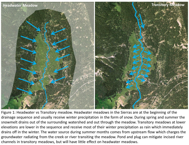
The hydrology for every Sierra meadow is dependent upon this cycle. However, the source of the water for a meadow in the Sierra is primarily dependent upon where it sits in the drainage sequence. Meadows can be characterized by their location as either a headwater meadows that is at the crest of the drainage and directly at the source of water (snow) or a transitory meadow which is lower in the drainage sequence and the water transits through on its way down the drainage slope. The number of headwater meadows is relatively small since the crest of the drainage slope is a small portion of the total area of the Sierras. Transitory meadows are much more prevalent.

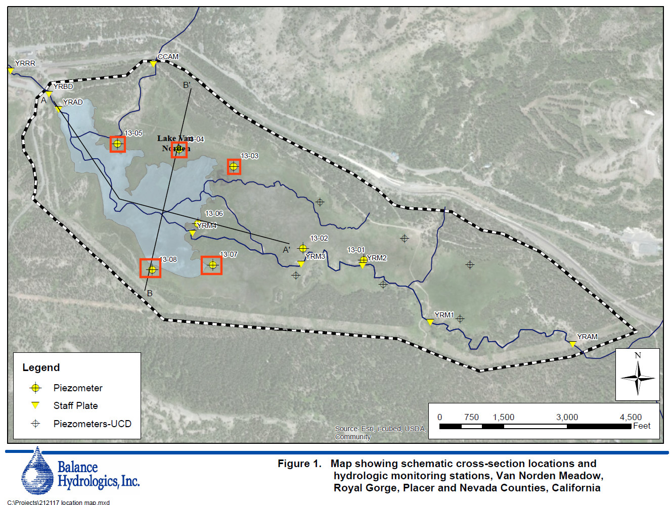
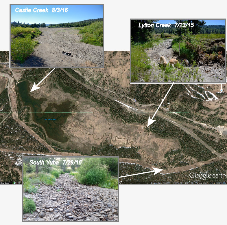
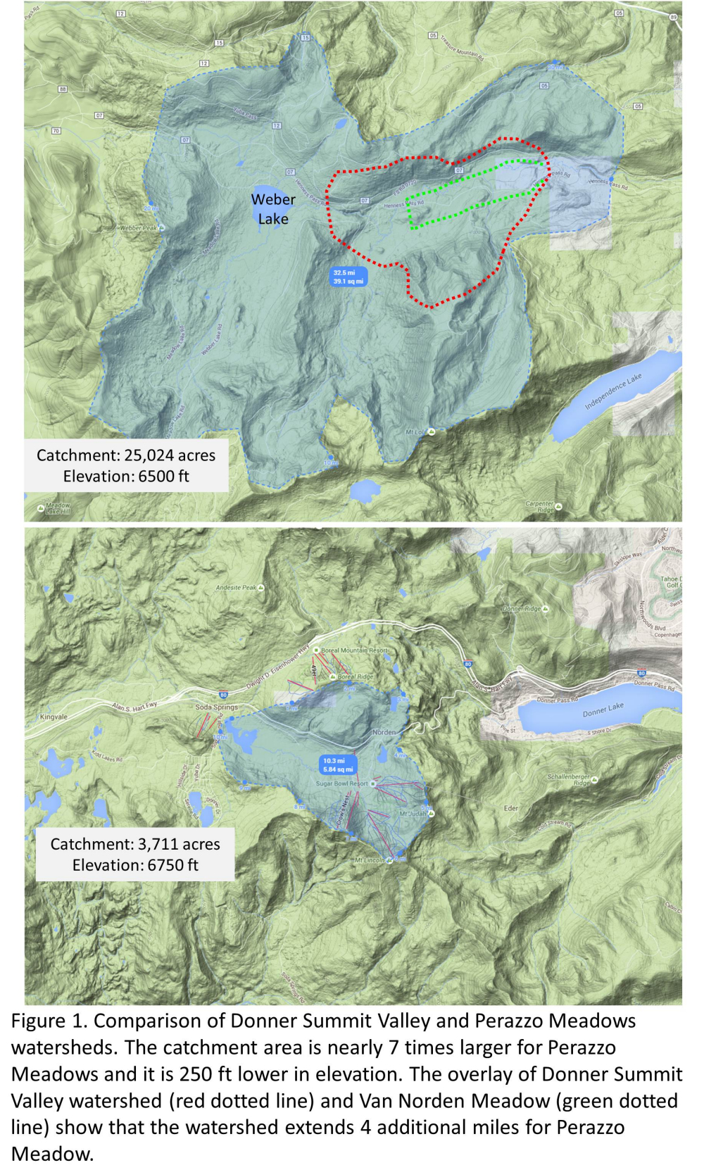
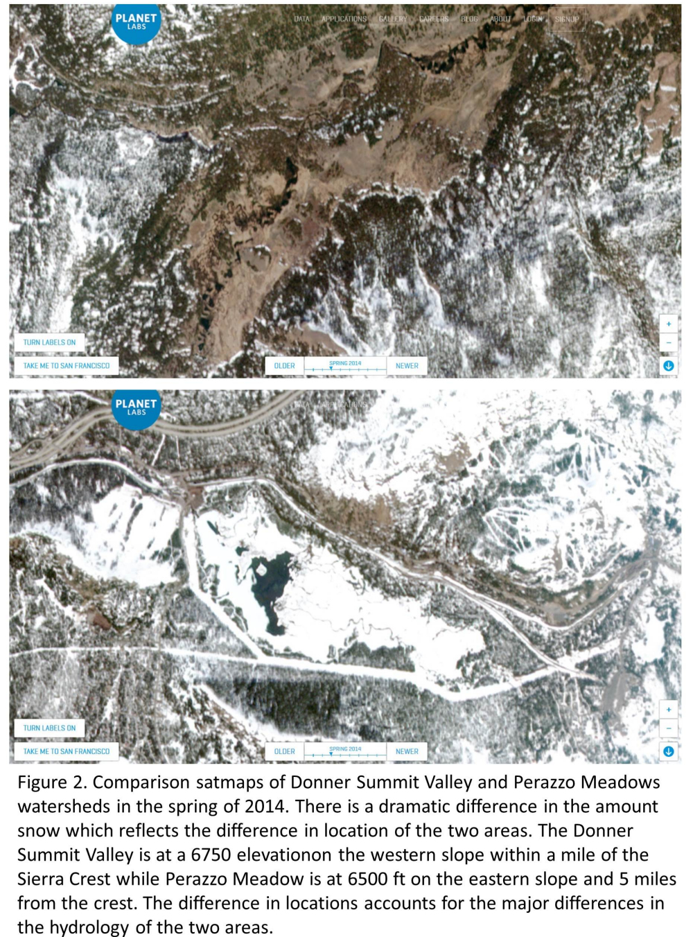
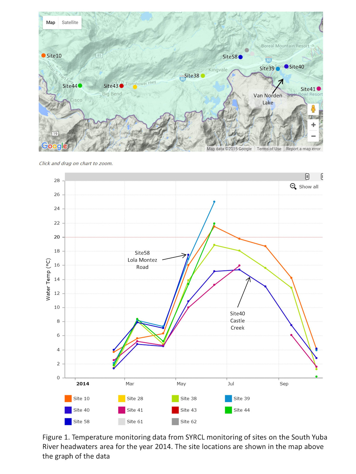
As you might expect the hydrology is quite different for these two types of meadow. That difference is illustrated in Figure 1. A headwater meadow such as the Summit Valley (see Figure 2) at the crest of the Sierras will normally be inundated with snow during the winter which sequesters the water during the winter months. It is not until the spring and summer months that the water is released by the melt and drains out of the meadow. Once the melt water drains from the meadow usually by mid-summer, there is no additional input of water until the winter snows come again.  Transitory meadows that are lower in the drainage sequence will receive most of winter precipitation in the form of rain which will quickly drain off. However, they will also receive water during the summer in the form of winter runoff from melting snow at higher elevations. That water usually transits through the meadow in a river or creek bed.

Meadow hydrology 4wp 2-10-16

Meadow Restoration

Most of the hype you will hear about meadow restoration has to do with modifying the drainage through a meadow. The popular method of doing this currently is a modification called “pond and plug” (or plug and pond). The concept behind this method is pretty simple. As water drains though a meadow it usually erodes out a channel at the low point forming a creek or river. The South Yuba River running through the Summit Valley is a perfect example. If the velocities of water flow are high like the heavy rains and snowmelt in the valley are prone to be, eventually the river bed cuts a channel below the flood plain of the meadow. When this happens the river is said to disconnect the water drainage from the flat floodplain of the meadow. This is what has come to be known as a “degraded” meadow and is the plight of many transitory meadows in the Sierras. While this erosional cutting down of the river banks is a natural process, it can be exacerbated in many meadows by human activities such as stock grazing, logging and recreational facilities such as ski resorts.

The obvious fix for a disconnected channel is to simply fill in the channel so that the water entering a transitory meadow will spread out over the flood plain again. This is really throwing a meadow back in time to a previous state before the erosion process has done its work. Not only can this be prohibitively expensive, but it is only a matter of time before erosion will re-cut the channel.

A modification of the fill in process was developed in the 1990s by David Rosgen, a hydrologist working for the Forest Service. He came up with a system of excavating short hardened plugs in an incised river channel. The plugs act as small dams that form a series of ponds along the river channel. When the spring melt waters enter a meadow the plugs force the ponds to overtop the channel banks and the water sheets out into the floodplain of the meadow. This method has been employed in many transitory meadows in many watersheds in the west over the last 20 years with varying degrees of success. While this method is not really natural (it does not really occur anywhere naturally in the Sierras) it has improved the state of many transitory meadows.

Donner Summit Valley is a headwater meadow – a double edged sword

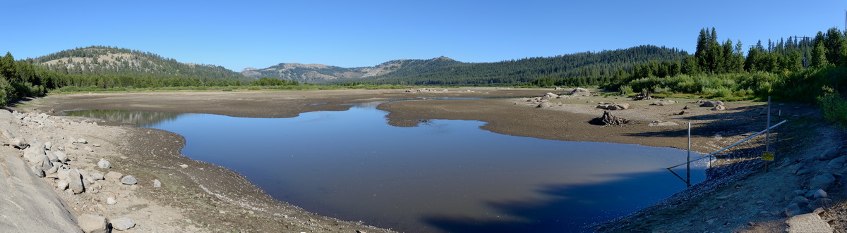
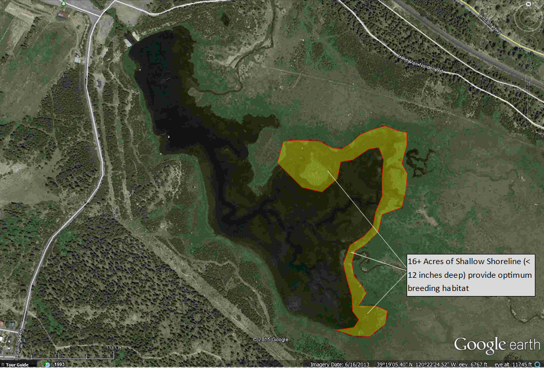
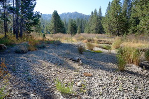
When people say that the Donner Summit Valley and Van Norden meadow are “special” places, it is not just rhetoric. The Donner Summit Valley is uniquely situated right at the Sierra crest and as such is a prototypical headwater meadow. The area receives 34 ft of snowfall on average making it one of the highest snowfall areas in the lower 48. This makes the hydrology of the Summit Valley very special and is the primary reason why the meadow thrives. And getting back to water storage, it is the reason that once Van Norden Lake is removed there will be much less water stored in the valley.

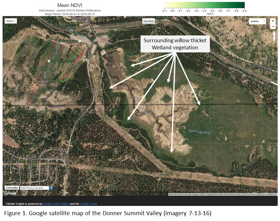
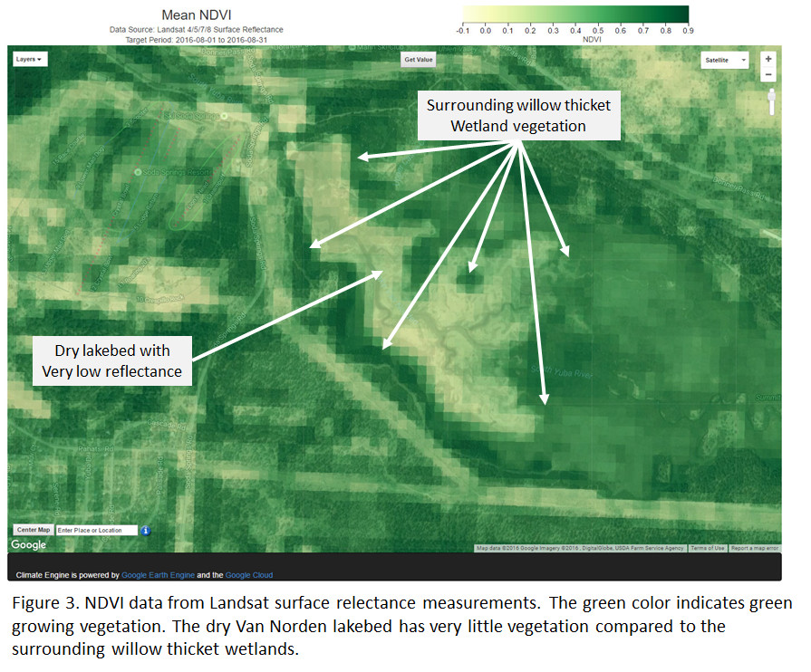
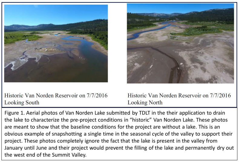
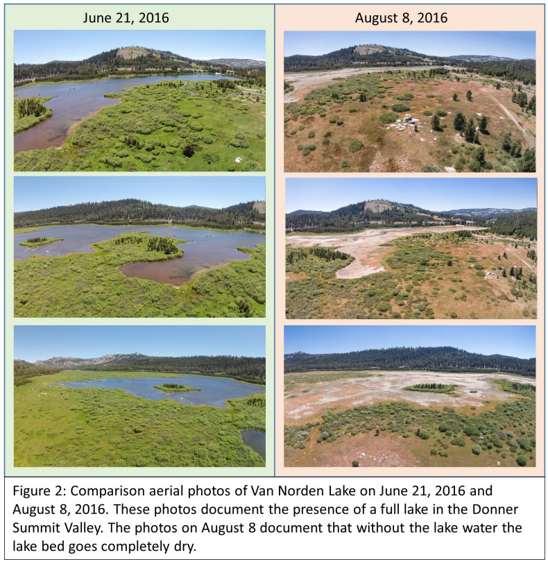
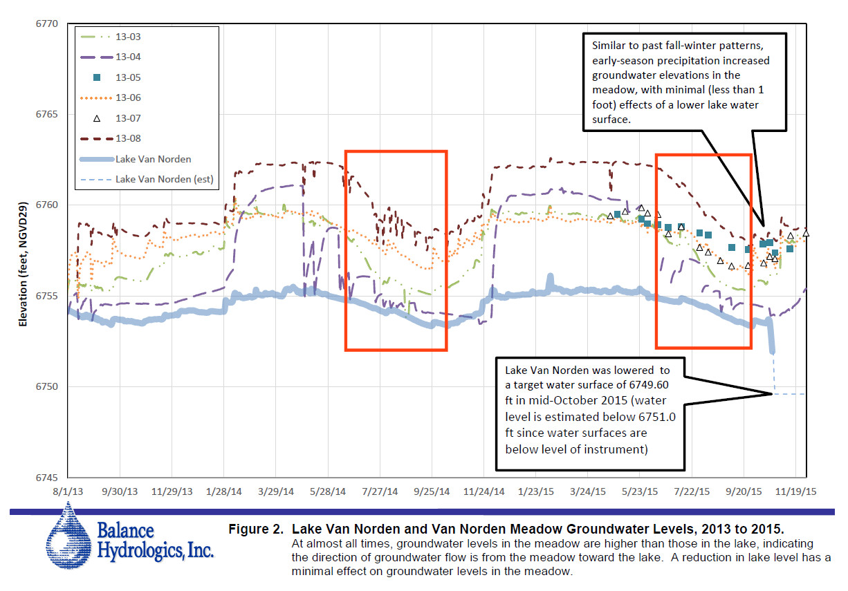
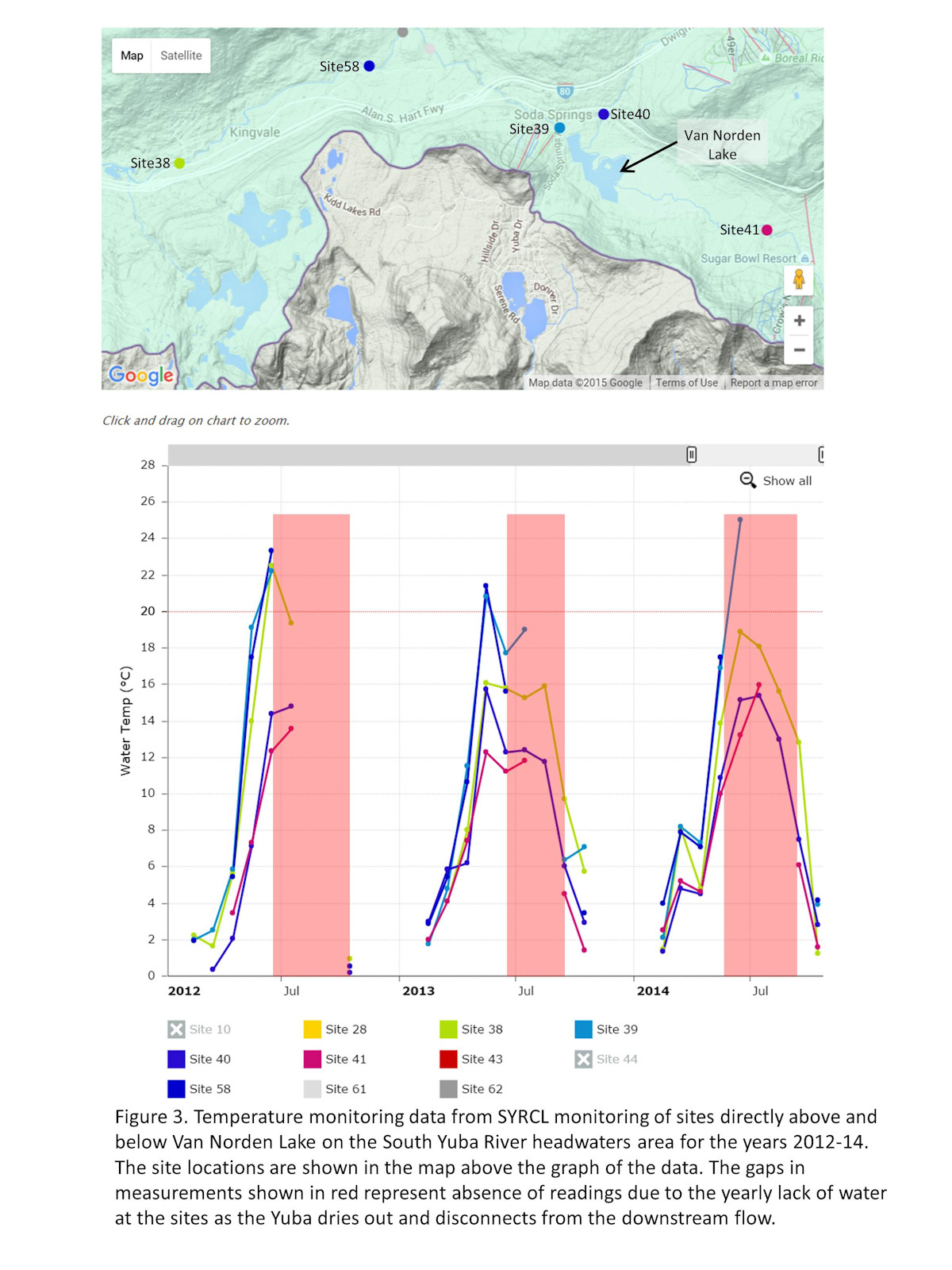
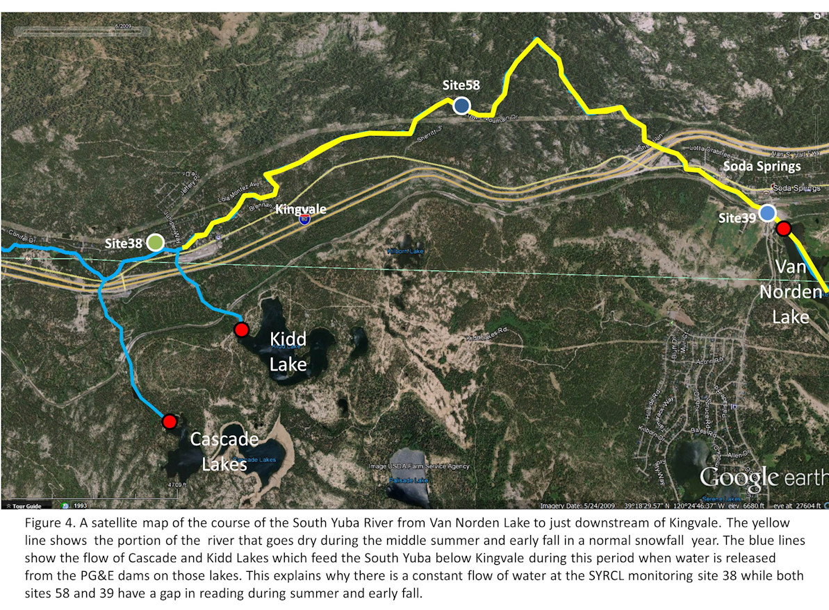
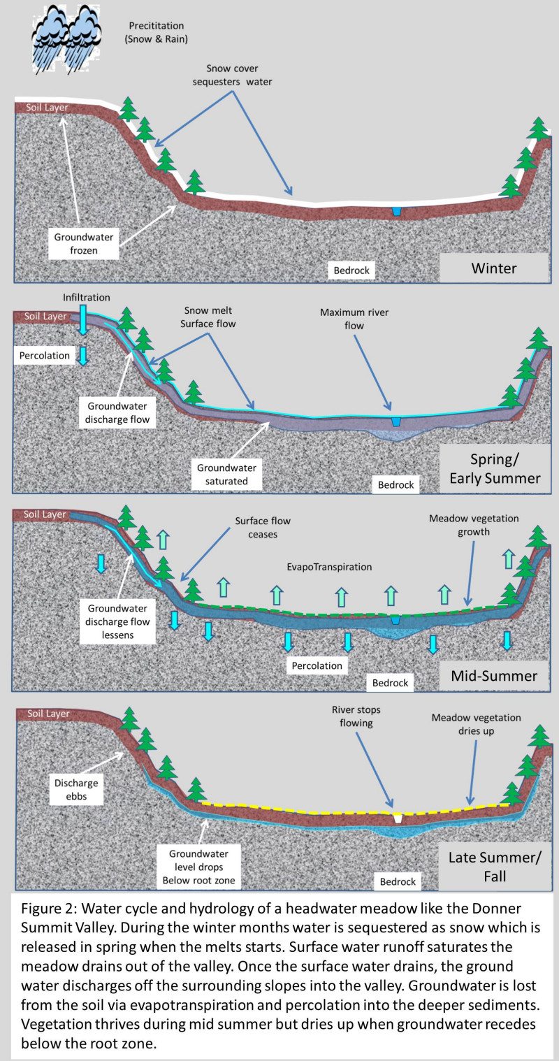
Unlike a transitory meadow, a headwater meadow like the Summit Valley is high at the source of the drainage sequence. While that means that it has a direct source of water from the accumulated snow, once it melts in spring and early summer and drains out of the valley, there is no more water coming down from upstream as in a transitory meadow. It also means that the unlike a transitory meadow where the input of water into the meadow comes from a river or creek upstream of the meadow, the water flow in a headwater meadow is one way drainage out of the meadow and down the drainage system, the South Yuba River in the case of the Summit Valley as shown in Figure 3. While the water is melting in the meadow and on the surrounding mountains there is a constant flow of surface water draining into the meadow which keeps the ground water saturated. Just walk out in the Summit Valley in May or June but be sure to wear your Welles because there is a sheet of 2-4 inches of surface water on the meadow. However, by the middle of July the surface water has drained out of the valley leaving only subterranean ground water.

Coup de Grass

evapotranspiration 4wpPlease excuse the pun here. By mid July the surface water has pretty much drained away leaving only the ground water in the valley. At this point we can use the “sponge” metaphor and say that the meadow is fully charged with water. However, according to the sponge metaphor, this would be the time when the ground water would be helping to maintain the flow of the Yuba River by seeping back into the river channel. This is where the sponge metaphor falls apart.

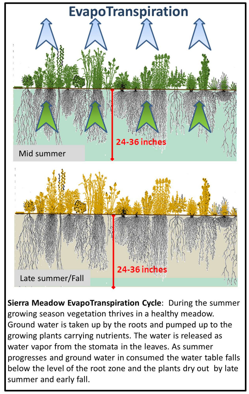
Up until this time in the cycle the major loss of water from the valley has been the natural drainage down the South Yuba River. Once that stops in mid summer (see this post) there is another natural process that becomes the major loss of water from the valley, evapotranspiration (ET). ET is the process that operates in plants in which water infuses into the roots of a plant and then is pumped up to carry nutrients up into the growing plant. Because the flow is primarily in one direction, the excess water is pumped out of the plants via openings called stomata on the leaves and stems. Once all the surface water has drained, a meadow becomes a battleground for all of the wonderful grasses, sedges, willows, trees and wildflowers that all try to suck water out of the soil to grow, flower and spread their seeds. As any farmer knows, it is the ET of their crops that is a major factor in how much water they need to irrigate with to bring in a harvest. ET completely breaks the sponge metaphor because it wrings the sponge dry so that by the middle of September all the ground water has been pumped out of the valley by the plant life which again goes dormant for another year when the ground water level drops below the typical root depth of 3-4 ft. This is when the Summit Valley turns to gold as the grasses dry out.

Water Storage

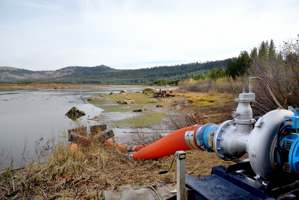
The first settlers in the Donner Summit area quickly learned about the natural water cycle of the Summit Valley. They realized that if they wanted to keep some water in the valley to last through summer they would have to dam the Yuba. As early as 1870 (just 25 years after the first pioneers passed through the valley) the first dam in the valley was being constructed. From that time until this, there has been a dam on the Yuba to store water in the valley during the dry summer and fall months.

So getting back to our absurd assertion, the Land Trust would have you believe that the current 180 acre-ft of water stored in Van Norden Lake can be replaced and even increased by draining the water and replacing it with meadow. This bit of hocus pocus will be done by “restoring” the meadow which will supposedly increase the overall ground water storage in the valley using methods such as pond and plug.

Here is why this just doesn’t work:

  • Currently the lake stores 180 acre feet of water and covers 70 acres of land that stays completely saturated during the summer. The lake is in fact the flood that is connected to the floodplain. Not only will the 180 acre-ft of water be lost, but the 70 acres of new meadow will no longer remain saturated during the summer and will be actively pumping water out of the valley via the ET process. Open water lakes where simple surface evaporation is at work are much more efficient at storing water than meadow where ground water is actively being pumped out by vegetation.
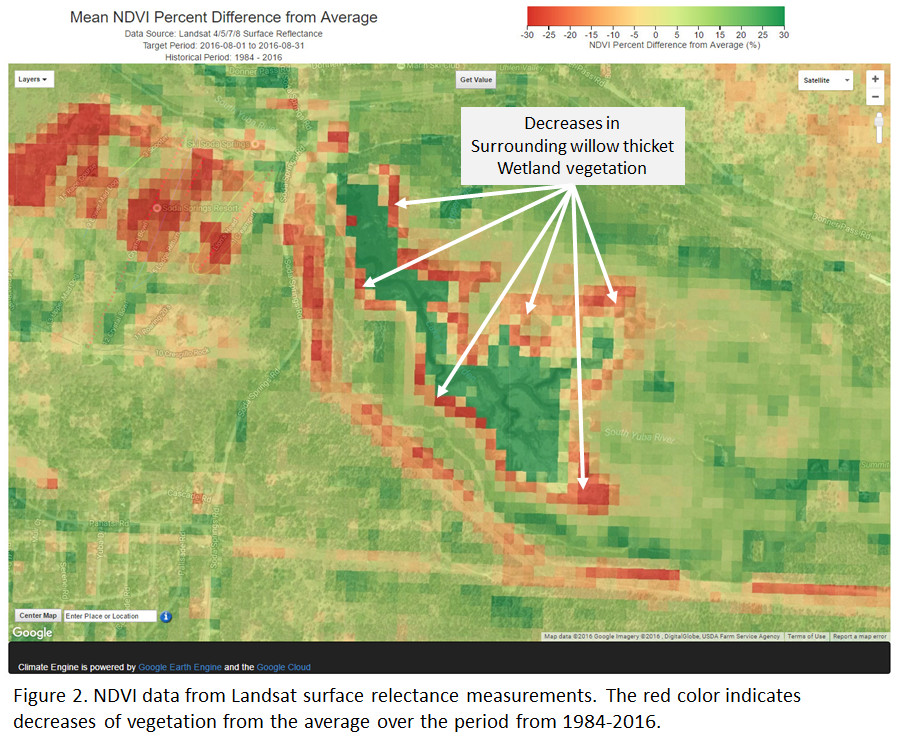
  • The pond and plug technique can only reconnect the floodplain when there is a constant source of water coming into a meadow to keep the water overtopping the banks of the ponds. This works well with transitory meadows being fed by upstream flows. I a situation where a transitory meadow has been disconnected from the creek flow, reconnecting the flow via pond and plug can increase storage in the meadow by recharging the groundwater. This is not the case for a headwater meadow like Donner Summit Valley where there is no upstream flow. The Donner Summit Valley remains inundated well into July due to snow melt drainage from the meadow and surrounding mountains. To increase the length of time the ground water aquifer would remain charged using a pond and plug restoration, there would have to be a continuous flow of water from the Yuba to keep the ponds overtopping their banks. Unfortunately, there is no more upstream input into the meadow after July (see this post) because the watershed has drained (see Figure 3).

pond and plug restoration4wp

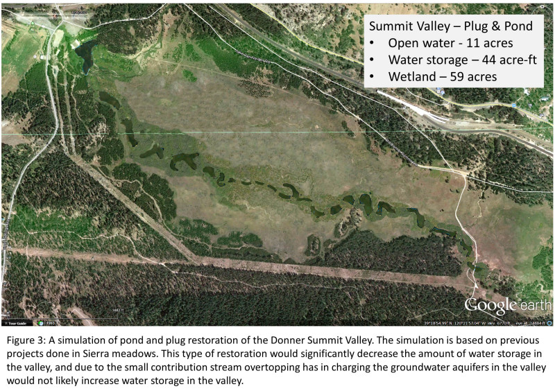
  • While there may be some added storage of open water at the east end of the Summit Valley with the installation of small ponds and plugs, this water will be a small fraction of what will be lost when the lake is drained at the west end of the valley (see Figure 3). Moreover, as summer progresses, the small amount of residual water in the ponds will be reduced by ET from the surrounding vegetation without replenishment from upstream.

The bottom line is that your common sense intuition is correct. Removing the Van Norden Lake from the Donner Summit Valley will significantly decrease the amount of water storage in the valley. Trying to apply concepts of meadow restoration that don’t really apply to a headwater meadow like the Summit Valley is misguided at best. Asserting that there will be more water storage without the lake is ABSURD.

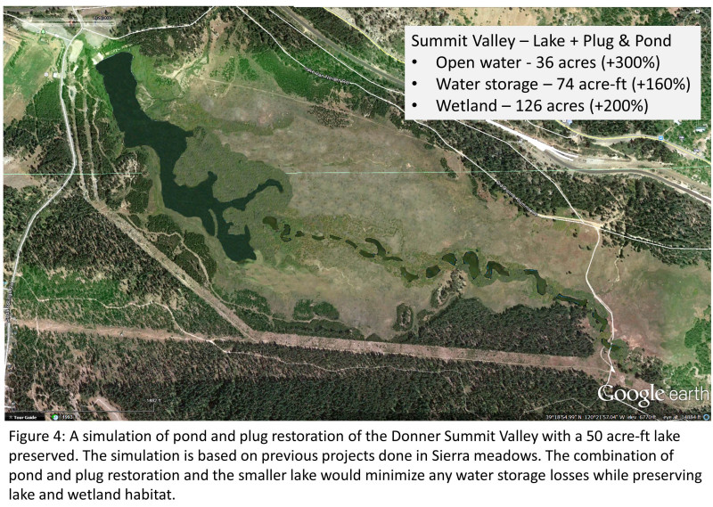
If the Truckee Donner Land Trust really wanted to maintain water storage in the Donner Summit Valley, we would encourage them to adopt our compromise plan that would maintain a 50 acre-ft lake in the valley. If they combined their meadow restoration plans with the retention of a small lake, they would minimize the amount of water storage loss due to the reduction of the current lake. At the same time they would be preserving the lake and wetlands habitats that add rich biodiversity to the Summit Valley. A win, win!

pond and plug with lake4wp


Posted in Uncategorized | 2 Comments

Draining Van Norden Lake – Absurd Assertions #2 – Van Norden Lake is bad for the Yuba

(Download a pdf of this post)

The Claims                                                                      

This week’s absurdity comes from the people at SYRCL, specifically their River Science Director that is coordinating the Environmental Assessment of TDLT’s plan to drain the lake and wetlands. We would refer you to her latest comments at the following link. It has been stated by some, that the “science” will decide the fate of Van Norden Lake. Unfortunately, as most working scientists know, scientific data can be inherently ambiguous and prone to multiple interpretations. In this article we will take a look at some of this ambiguity as it applies to the Donner Summit Valley.

While we recommend that you read the full article, we would like to address what we believe is the primary point of the article which is that Van Norden Lake has adverse effects on the Yuba River downstream of the dam. To support this assertion the article cites the “serial discontinuity” theory that states that impoundments of water in lakes within a river system will have significant effects on that system. The references are pretty technical and while Van Norden Lake doesn’t really fit into the strict tenets of this theory, I don’t think anyone would be surprised that there would be differences between lake and river habitats and they would affect each other. If you dive into the literature concerning lake and river systems you quickly realize that these fields of study are not always in agreement (see this paper supporting the advantages of the integration of lakes and rivers in a drainage system). Unfortunately, as with many complex ecological systems, there is not enough data to provide a definitive description of all the processes that are involved and their positive and negative effects.

The Reality

flyoverlink

Don’t miss the flyover of the dry Yuba

Fortunately, we don’t really have to be concerned about whose theory is correct or even, contrary to the SYRCL article, whether Van Norden Lake adversely affects the downstream Yuba. To understand why Van Norden Lake doesn’t really have profound effects on the Yuba downstream, let’s take a look at some of the data provided by none other than, SYRCL. In their article, SYRCL included a pretty much unreadable graph that purportedly points to Van Norden Lake as the cause of a temperature elevation in the downstream Yuba. However, if you go to the actual raw data that they provide (kudos to whoever designed their interactive webpage) you can get a clearer picture of what is actually going on. You can view the water temperature data in detail for 2014 in Figure 1.

In order to understand this data it is important to know the locations of the monitoring stations which are shown on the map above the graph in Figure1 and the yearly seasonal cycle of Donner Summit Valley. The monitoring sites at Castle Creek (site 40) and the South Yuba headwaters (site41) are above the meadow and lake and sites 38, 39, 58 and  are below the dam (Unfortunately, the colors for Sites 40 and 58 are very similar and those sites are identified on the maps).

Yuba dry riverbed in Setember upstream of Van Norden meadow

Yuba dry riverbed in Setember upstream of Van Norden meadow

The yearly water cycle of the Donner Summit Valley is somewhat unique in that the area experiences some of the highest snowfall amounts in California with an average of 34 ft (see this link). As a result water is sequestered as snow from the months of November to April or May and the South Yuba, Castle Creek, and Van Norden Lake remain frozen during this period. In normal and dry years the flow down the Yuba is minimal during this period (unless there are heavy winter rains).

It is not until the spring melt in April and May that the flow down the Yuba starts in earnest and as we will see by the data discussed below, that flow comes to an end in mid summer. The reality is that other than the period from April to July, for much of the year the Donner Summit Valley and Van Norden Lake and Meadow are effectively disconnected from the flow of the downstream South Yuba and as a result have very little influence on it.

Absurd Assertions2-Figure1 4web

Taking a closer look – The big disconnect

As with most things in this world the devil is in the details, so let’s look a little closer at the data. The same temperature data for 2014 is shown in Figure 2 for just the sites immediately upstream and downstream of the lake and meadow. The site at Kingvale is also included for reasons that will be explained below.

Absurd Assertions2-Figure2 4web

As is often the case in science it is important to look at all aspects of the data. In order to understand that Van Norden Lake has very little influence on the downstream Yuba it is important to look at the frequencies of the temperature readings at the upstream and downstream sites instead of the values of the temperature readings.

Dry input of Yuba into Van Noden Lake - September

Dry input of Yuba into Van Noden Lake – September

You will notice that there are not contiguous readings for Sites 58, 39 and 41 during the summer and early fall. The reason for these gaps is due to the fact that during these months there is no water flowing to take temperature readings. What this data shows is really the crux of the situation with the Yuba River in the Summit Valley. The fact is that vast majority of water drains out of the Summit Valley from April through June and there is not enough water coming out of the watershed during the summer and early fall to keep the River flowing past July. As a result, the Donner Summit Valley is disconnected from the downstream Yuba River during that period.

As the data shows, the disconnect starts downstream at Site 58 in early summer and then moves up to the output of the dam in midsummer and is finally disconnected from the upper Yuba when it goes dry in late summer (see the August flyover video below).

Dry input of Castle Creek into Van Noden Lake - October

Dry input of Castle Creek into Van Noden Lake – October

While the input from Castle Creek continues during the summer, it is at such a low flow that it is dissipated when it enters the meadow and is not enough to supply the Yuba. The simple truth of the matter is, contrary to what has been stated by SYRCL, for most of the summer and early fall Van Norden Lake is disconnected from the downstream Yuba and really has no effect at all. And lest you think that this disconnection is due to the dam, keep in mind that the 180 acre-ft of water that is in the current lake is less than a day of flow down the Yuba during the melt. This natural disconnection has always occurred in the Summit Valley except in the heavier snowfall years. It is part of the reason that the valley probably never supported a fish population. The yearly occurrence of this phenomenon is shown in Figure 3 which shows data for the last 3 years showing that each year the Yuba disconnects during the summer months.

Absurd Assertions2-Figure3 4web

Looking Downstream

It is SYRCL’s claim that Van Norden Lake adversely affects the downstream Yuba River by raising the temperature above 20° C. Their own data show that this in fact cannot really happen because the Yuba realy goes dry below Van Norden Lake (see our flyover of the Yuba below). You may be saying to yourself right now, wait a minute, what about site 38 just below Kingvale which shows continuous flow all year? This is where things get really interesting. If water is not coming down the Yuba above Kingvale, how is it that there can be a nice cool supply of water running all year from Kingvale down to Cisco and beyond.  The answer to that riddle is shown in Figure 4.  It turns out that there are three small lakes, Kidd and Upper and Lower Cascade, up on the ridge south of Kingvale that have PG&E dams on them.

Absurd Assertions2-Figure4 4web

During the summer months water is released from these lakes and it flows down into the Yuba just below Kingvale and provides the water to keep the Yuba alive from Kingvale on. The real irony is that when Van Norden Lake was operated as a full 5800 acre-ft lake, cool water was released from the bottom of the lake every year to keep a continuous flow of the Yuba all year. You really have to scratch your head and wonder how the SYRCL Science Director can claim that they are concerned about keeping the river connected when the only time the river was truly connected was when there was much more “cement” involved. It is unfortunate that SYRCL cannot let go of its overpowering anti-dam bias to see that in fact the only reason that there is a flowing upper Yuba River for a good part of the year is due to strategically placed dams.

We should point out another misconception that is being fostered by SYRCL and TDLT concerning their proposed plan for breaching Van Norden dam. The Science Director claims that the plan will “reconnect” the Yuba flowing in the Summit Valley. This is incorrect. The announced plan by TDLT calls for a breach of the dam to lower it 5 ft. While lowering the dam to this level will effectively drain the lake and lower the water table in the valley by 5 ft, the spillway will remain and the Yuba in the Summit Valley will continue to disconnect from the downstream river every summer. The plan will do nothing to change the downstream flow (or no flow) of the Yuba. What it will do is remove the lake so that TDLT can sell the land to the US Forest Service for $2 million dollars.

One of the tenets of the scientific method is to try to minimize bias in the collection and analysis of data. There is a real danger when science is done to further an agenda. The literature is littered with discredited work done to further a personal bias or agenda. The Donner Summit Valley and Van Norden Lake and Meadow are unique high elevation resources sitting at the headwaters of the South Yuba River. The unique combination of local weather and habitats requires that any analyses take those unique attributes into account. Applying principles and methods from different ecological environments can not only lead to invalid conclusions, but can also be detrimental. Van Norden Lake and its surrounding wetlands are the result of some very unique influences, both natural and manmade. The result is a unique combination of habitats that foster increased biodiversity in the Summit Valley. Considering the local contribution that these unique habitats make to the Donner Summit Valley and the fact that they do not really affect the downstream Yuba River, it seems only prudent to preserve them.

And for Next time

We would expect that SYRCL and TDLT might respond to this article with a claim that their future “meadow restoration” plan will magically provide more water to the valley. In our next installment we will discuss some of the fallacies and misconceptions of what meadow restoration can really do in the Donner Summit Valley.

Fly over the Summit Valley during the dry summer

The following flyover is from Google Earth in August of 2012. It shows how the Yuba goes dry in summer down to Kingvale. The Yuba stays dry until the rains come in the fall and it is covered by snow in the winter.

Posted in Uncategorized | 2 Comments