Why Lake Van Norden is so special to the Donner Summit Valley

We had an amazing encounter on Lake Van Norden this week that really brings home why the lake is so special to the Donner Summit Valley. In this incredible year where we have already been kayaking on the lake twice, we were rewarded this week with a wildlife moment that will not be possible in the future if the lake and wetlands is drained.

CNX2_750_0543

See that little dot. That’s an eagle.

A couple of days ago we loaded the kayaks into the pickup and headed down for our second paddle out on Van Norden Lake. That in itself is pretty special in March. As we started paddling east out into the lake from the spillway we spotted a couple of raptors skimming over the lake. At first I thought it was a couple of early Ospreys out fishing. As we got closer and got the binocs on them we were thrilled to see it was a pair of Bald Eagles, an adult and a juvenile. As we paddled out they flew up into a couple of tall pines to rest after their fishing. I got a couple of those “see that dot in the tree, that’s an eagle” shots which is what I usually get.

We continued out to the north end of the back bay area of the lake to check on whether the Western Toads had started their annual mating season in the shallow waters of that area of the lake. To our surprise, they had. We saw many toad heads bobbing on the surface and lots of courtship action, but that’s another story. As we were watching the toads all of a sudden this huge shape dove out of the air above us and scooped up a young fish about 30 yards from us. It was the juvenile Eagle. It proceeded to land on a rock about 10 yards from us and eat its catch. It seemed to be completely oblivious to us despite our close proximity. Needless to say, I was happily snapping away as it calmly devoured its meal and then sunned itself on the rock. It stayed on that rock for about ten minutes preening itself. I felt like the nature paparazzi.

eagle1

eagle2

Yum!


When you bring up the point that majestic animals like the Bald Eagle, Osprey and White Pelican will no longer come to the valley to fish, you will hear some people say “well those animals are not endangered”. My reply is that like the old addage that all politics are local, the same goes for the natural environment. Those animals are very much endangered in the Donner Summit Valley right now and will become “extinct” there without the lake habitat that provides the fish they live on. Knowing that these animals may be living somewhere else does not replace the thrill of encountering them close up and personal right in our own backyard.

Posted in Uncategorized | Leave a comment

Bringing New Conservation to Donner Summit Valley

Conservation efforts in today’s changing world are experiencing a wave of new ideas. This change in traditional thinking was recently discussed in a New York Times article and is also championed by the authors David Cole and Laurie Yung in their book “Beyond Naturalness” (2010, Island Press), both of  which we highly recommend. Rather than thinking of nature conservation as a rigid back to past policy, the new conservation looks forward to the expected changes in climate and development and tries to adapt to optimize the natural environment to that reality.

There are some real lessons from this new way of thinking that apply to the current efforts going on in the Donner Summit Valley. The Truckee Donner Land Trust and US Forest service are currently considering a plan for a classic “restoration” of the meadow in the Summit Valley. The plan proposes to return the meadow to the seasonal wet meadow that existed before the pioneers came to California. A very classical conservation approach.


Summit valley historical comparison

What the plan does not take into account is that as a result of a serendipitous chain of events over the last 150 years, nature has established a new set of habitats in the valley in addition to the existing seasonal wet meadow. The remnants of the PG&E Van Norden Dam have, much like a glacial moraine, created a unique area of shallow open water lake and surrounding wetlands that over the last 3 decades have established new habitats that have provided the Summit Valley with rich new biodiversity. In a world of warming climate and the threat of continuing drought for California, this new lake and wetland habitat is an a oasis against the changing Sierra landscape.

We see the conservation of Van Norden Lake and wetlands as a page right out of the new conservation movement. It does not make sense to destroy the unique and valuable aquatic habitat that has successfully established itself in the valley for the sake of trying to expand a traditional landscape that already exists in the majority of the valley. It would seem to us that nature should be the arbiter of what the future of the valley should look like and for all intents and purposes nature has made its decision. When given the chance, nature always opts to increase diversity.

Posted in Uncategorized | Tagged , , , | Leave a comment

Despite our best efforts, the struggle continues…

This site has been quiet for a number of months now, but we want you to know that it was not because we had reduced our efforts. Quite to the contrary, we have been concentrating our efforts on a proposition that we hoped would solve the dilemma of preserving Van Norden Lake and its wetlands.

As many of you probably know, we made an offer to Truckee Donner Land Trust (TDLT) last July to buy a portion of the Summit Valley property that contained the lake and surrounding wetlands (See Figure 1). Our purpose was to offer an alternative buyer to the US Forest Service, that would remove their requirement to drain the lake and wetlands. We offered TDLT $400,000 for the property which we felt was fair considering that the property represented about 20% of the entire property. vnmpurchasemap

Figure 1. Map of proposed parcels in original purchase offer to TDLT.

Our offer included the provision that a permanent conservation easement would be applied to the land under the auspices of a non-profit organization that we would set up to administer the land. Our offer was rejected by TDLT on the grounds (if you can believe this) that our plan to preserve the lake and wetlands was contrary to the intent of the donors that contributed funds for the acquisition of the land. I know many of you reading this were donors like me who thought that was exactly what we were contributing the money for.

All was not lost, however. TDLT made a counter offer in which they would retain the ownership of the lake property, apply for the water rights to maintain a 49 acre-ft lake and notch the dam 2.2 ft to create a lake of that size. What they wanted from us was the promise that we would not oppose them during the CEQA approval process. Oh yeah and they wanted us to pay $50,000 to them to fund the effort to obtain the water rights and once the water rights were obtained we would make additional $150,000 contribution to TDLT for the future maintenance of the area. We did not in any way see this as a victory since a 49 acre-ft lake would still result in over a 60% reduction in the lake and wetlands. But we did see it as a compromise that would at least retain some lake and wetland in the valley. And so for the last 3 months we have been seriously negotiating with TDLT to make this deal a reality.

Sadly, we could not make this deal work. While we were very close, it turned out that just as before we made our offer, it was the Forest Service which proved to be the final problem. While TDLT agreed to retaining the 49 acre-ft lake, the Forest Service would not make any commitments to maintaining the lake and wetlands. In order to remove the Forest Service from the fray we proposed that TDLT retain a parcel that included 70% of the proposed lake (see Figure 2).

lakeparcelmap

Figure 2. Map of different parcels to be retained by TDLT.

The Forest Service refused to let TDLT retain the property containing the lake, but would agree to only the 14 acres that contained the dam. They also refused to give any sort of written agreement or easement for the TDLT to store 49 acre-ft of water on the remaining land once they acquired it. Since the Forest Service refused to participate in the agreement at all, we felt that we were right back where we started in that they would have complete control of the future of the lake with no commitment to carrying out our agreement with TDLT. This did not seem like a prudent investment of our $200,000.

All was not lost in this effort. We learned some very valuable information in our negotiations with TDLT.

  • It is clear that TDLT does not really believe that a 49 acre-ft lake in the valley poses a threat to public safety as they had previously stated.
  • It is also clear that there is a good possibility that water rights for a 49 acre-ft lake are obtainable.
  • Finally, as we have contended all along it is really not necessary to completely drain the lake and wetlands and in fact even TDLT is willing to incorporate the presence of the lake and wetlands into their plans for the future of the Summit Valley.

So the struggle continues!

We will be describing our next steps in future posts, so please stand by.


Posted in Uncategorized | Leave a comment

Lodgepole Meadow?

Preserving wild places may require more human intervention. This somewhat counter intuitive statement is the thrust of an opinion article in the New York Times by Christopher Solomon a few days ago (click here to read the article). The article is a discussion about how the Wilderness Act is facing some changes in the new world of climate change. It puts forth some interesting facts about the challenges wilderness areas are facing and some ideas about how human intervention may be needed to preserve wilderness areas. We recommend everyone concerned with open space preservation take a look.

While the Donner Summit Valley would not technically be considered a wilderness area, as an open space area it does face many of the problems that are discussed in the article.  Human intervention has had both good and bad effects in the valley. Intense logging of the valley changed the old growth red fir and white pine forests to predominantly thick lodgepole forests. Years of sheep and cattle grazing took it’s toll on the valley right up until the 1950’s. The presence of a large PG&E storage lake covered half the meadow in water for over 100 years. Fortunately, in the last 40-50 years the valley has pretty much been left on its own and nature as the consummate environmentalist has established a thriving blend of lake, wetlands, riparian and meadow habitats that make it an oasis of biodiversity in the Sierras. As a bendficial affect of human intervention, the addition of added water storage in the valley as a result of the residual Van Norden Dam is responsible for offsetting many of the negative affects of past exploitation of the valley.

There is a segment of the wilderness article that is particularly relevant to a threat that the Summit Valley faces today. I include here that paragraph

Tuolumne Meadows in Yosemite National Park is one of the most arresting places in the West, and it’s important as the largest subalpine meadow in the Sierra Nevada.

But as the climate changes, the meadows, some of which lie in the Yosemite Wilderness, are being invaded by lodgepole pine. Keeping the meadows intact will require regular tree-cutting and possibly irrigation for species intolerant of drier conditions, according to David Cole, an emeritus scientist with the Forest Service’s Aldo Leopold Wilderness Research Institute and co-editor of “Beyond Naturalness,” a 2010 book of scholarly essays about wilderness and climate change.

That’s right, they may have to irrigate Tuolumne Meadows to keep it a meadow the Lodgepoles out.

Lodgepolepinecomparison7-7-14Anyone that has been out in the Summit Valley knows that there is an active invasion of Lodgepole pines going on. Before 1976 when the dam was breached to create the current lake, the large 5800 acre-ft lake prevented the Lodgepoles from coming into the valley. But when the lake was reduced to its current size, the Lodgepoles (which can grow at a density of 1000 trees per acre) took advantage of the drier meadow and the invasion was on. The encroachment of Lodgepoles can clearly be seen in Figure 1 in which satellite maps from 1979 and 2012 show the results of the invasion. In those 38 years dense thickets of trees have sprung up and started marching out into the valley until they hit the surface water table of the lake and wetlands. Without the lake and wetlands there will be nothing to stop the march of the Lodgepoles out into the meadow, just like what is occurring in Tuolumne Meadows as they dry out. In drought years such as this there will be dense stands of dry Lodgepoles. A perfect target for wildfires. This is yet another of the detrimental effects that the draining of the lake and wetlands will have on the Summit Valley. Keeping the meadow opened would require a continuous tree cutting program by its stewards (the Land Trust and the Forest Service). And how crazy would it be if the lake and wetlands were drained and then eventually the valley had to irrigated to help prevent encroachment and support meadow vegetation.


Reiterating the theme of increased water storage that we made in the last post, it seems that the human intervention that created the current lake bolsters the premise made in the New York Times article. In many situations, the hand of man can greatly enhance the natural processes to create a richer, more verdant ecosystem.


Posted in Uncategorized | Leave a comment

Jim Morgan favors increased water storage in the Northern Sierra

In the last week a few people have forwarded to us an article by Jim Morgan, a dedicated and prominent environmentalist in the Northern Sierras and the president of the Northern Sierra Partnership’s Governing Council. The article was apparently being sent by the Truckee Donner Land Trust (TDLT) in support of their current plans for the Donner Summit Valley. This excellent article stresses the critical need for increased water storage in the Northern Sierra in light of coming climate change and increased threat of drought. We highly recommend that everyone that is concerned about the future of the Sierras and California read this article (click here).

Summit Valley water storage before and after notching the Van Norden Dam by 5 ft.


As strong supporters for preservation of Van Norden Lake and wetlands we were heartened to see that leaders in the field such as Jim Morgan support the importance of water storage in the Sierras. We have already discussed similar views by Dr Charles Goldman in a previous post. We found it somewhat puzzling however, that TDLT was distributing this article ostensibly in support of their plan to drain the primary water resource in the Donner Summit Valley. Their plan to lower the water table in the valley by 5 ft and drain a lake of over 180 acre-ft and its surrounding wetlands thereby decreasing water storage in the valley by 96% flies in the face of everything that the article is proposing. It must have been the one reference to “meadow restoration” as one means of increasing water storage that prompted TDLT to miss the main point of the article. Of course the restoration of many of the dry meadows in the Sierras with state of the art techniques will help to improve water storage in those meadows. The Perrazo Meadow area is a perfect example of how these techniques can work to improve water storage.

What TDLT seems to have missed is that unlike Perrazo Meadows, the Donner Summit Valley is not a dry meadow in need of restoration. It does in fact support a valuable lake that charges the acquifer of the entire valley. Following the logic and direction of Jim Morgan’s article, it would make sense at the very least to preserve the current water storage in the valley, as we propose. You could even make the argument, as many have, that increasing the size of the lake and adding more valuable water storage would be more in keeping with the emphasis of the article. We would hope that TDLT take a closer look at this article and reconsider their plan to decrease the much needed waters in Van Norden Lake and wetlands.

Posted in Uncategorized | Leave a comment

Dr Charles Goldman Weighs In on Van Norden Lake & Wetlands

goldmanbannerYou have read a lot of information on this site that we have prepared. We thought you might want to hear what some others have to say about preserving Van Norden Lake and its wetlands. Dr Charles Goldman is a world renowned expert on lakes (limnology) and has been a major contributor to the preservation and restoration of lakes and wetlands all over the world, and especially Lake Tahoe and the Sierras (read Dr. Goldman’s extensive CV). You can read about the important work that Dr. Goldman has done in the references listed below. Here, we would like to showcase the two letters that Dr Goldman has written to the board of the Truckee Donner Land Trust concerning Van Norden Lake and its wetlands. The letters speak for themselves.

The first letter was written in June of 2013, before TDLT switched its plan to draining the the majority of the lake:

Click to download a pdf
Goldman letter 6-13

The second letter was written this May when it was discovered that TDLT had changed to its current plan to drain the majority of lake and wetlands and when Dr. Goldman had received no reply to his first letter.

Click to download a pdf
Goldman letter 5-14


Posted in Uncategorized | Leave a comment

The “Blue Paper” and an open letter to Truckee Donner Land Trust

In the past few weeks we have spent a considerable amount of time investigating the claims that have been made by the U.S Forest Service and the Truckee Donner Land Trust (TDLT) to support their drastic action of draining Van Norden Lake and Meadow. The culmination of that research has been summarized in a document we are calling the Blue Paper – The Future of Summit Valley. We have strived to not only present data to refute the statements that have been made both by the TDLT and the Forest Service, but also to provide authoritative references and agency contact information to support our assertions.

We urge everyone to read the Blue Paper and consult the references to make sure you know all of the facts so that you can make a fully informed decision about what the the best course of action is for the Summit Valley. We have also written an open letter to TDLT in which we challenge them to return to their core values of preservation and avoid an irreversible environmental mistake that will drastically destroy a unique and vital natural jewel in the Summit Valley.

Click to view entire document
BluePaper6-28-14

Open letter to TDLT 6-14


Posted in Uncategorized | Leave a comment

The “Report” – If you don’t read anything else, READ THIS

Download pdf of this post

The entire controversy over draining Van Norden Lake and wetlands is based on the contention that the Van Norden dam has been classified a “significant hazard” and as such the US Forest Service refuses to buy the land with the dam on it. We contend that it is in fact the Yuba River that poses the significant flood hazard as shown by hydraulic evaluation and that the Van Norden Dam provides significant hazard prevention through potential flood control.

The Forest Service definition of significant hazard is defined on page 13 of the Forest Service Manual FSM 7500 as

Significant.  A classification that includes dams whose failure, malfunction, or misoperation would result in no probable loss of human life but could cause economic loss, disruption of lifeline facilities, or other significant impacts and would result in non-recoverable environmental damage. 

To be clear, threat to loss of life is not the issue with this classification. The hazard is to economic loss, lifeline facilities and environmental damage. Furthermore, this classification has nothing to with the reliability of the dam or the probability that it will fail, which is very low.

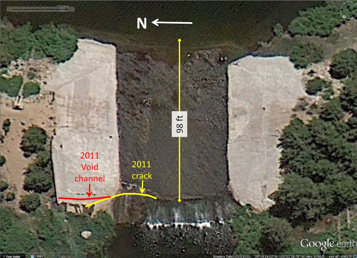
In light of the fact that the Forest Service is trying to force the Truckee Donner Land Trust to drain the lake and wetlands based on this classification, the crucial question is how was it derived. The answer has been a bit of a mystery for us until this week. We knew that it was the result of a hydraulic evaluation by the company Balance Hydrologics, but the report was never released to the public. Fortunately we live in a country where our government keeps tabs on things like public safety and makes that information available to the public. The California Department of Safety of Dams (DSOD) keeps a public record of all documents concerning all of our dams, including Van Norden Dam. On a visit to their Sacramento office this week, we found the Balance Hydrologics report which we have put online for public scrutiny.

We urge everyone to take a look at the report. This is a pretty technical report so don’t be put off by the first 6 pages that use the technical jargon of the hydrology field. Suffice it to say that for the most part, Balance Hydrologics is using standard practices to perform the analysis. There is one parameter that is very important to the analysis that should be noted.The Breach Formation Time on page 5 was determined to be 1 hour. This means that we are not talking about a sudden failure that releases a wall of water down the Yuba.

The crux of the report starts with the RESULTS section on page 7. The first section, the Sunny Day Breach, makes it clear that while it would be an event to see, the banks of the Yuba would contain the added flow from a breach under normal conditions. The real question of course is what happens if the breach were to occur during a storm. That scenario is covered by the Design Flood scenario. This quickly gets complicated, but the results can be visualized in Figure 1.

Flood graphics

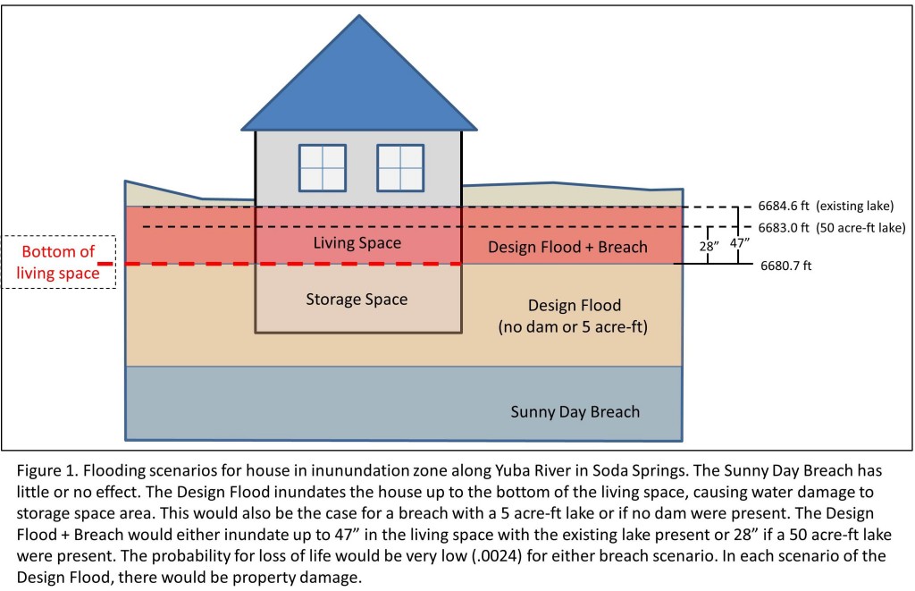
The important results of the scenario are

  • The design flood was theoretically designed to be at the “tipping point” in which the level of the Yuba would be at the bottom of the living quarters for the only 2 houses in the inundation zone of the flood. This 1 in 120 year event was to measure the added contribution of a breach. There will still be property damage to the lower non-living sections of the homes at this level.
  • The added contribution of a breach for the existing 190 acre-ft lake raised the level of the water in the living quarters by 47 inches over the one hour breach time. There would still be property damage to the home.
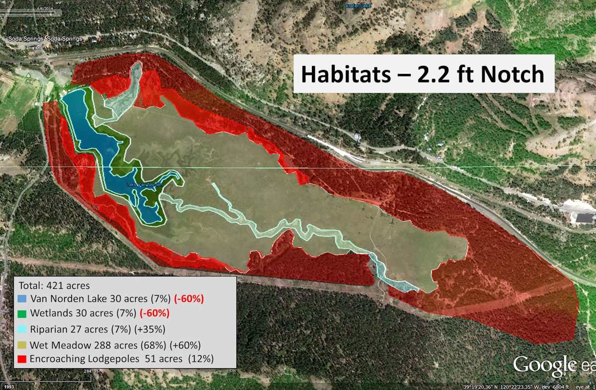
  • Under conditions in which the lake contained only 50 acre-ft, the level only rose 28 inches. There would still be property damage.
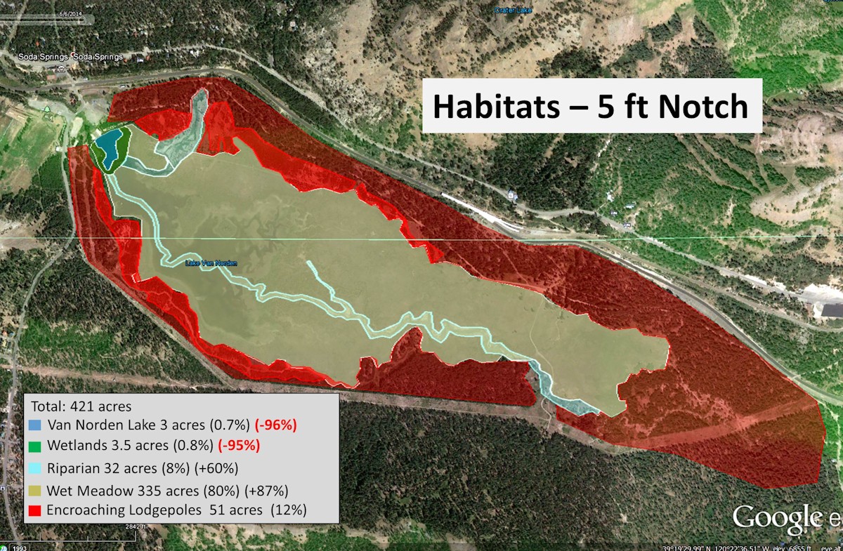
  • Under conditions in which the lake only contained 5 acre-ft (the level acceptable to the Forest Service), the level only rose 1 inch into living quarter. However, there would still be property damage.

The most important part of the report of course is the evaluation of the hazard posed to loss of life in this scenario. The crucial finding from the detailed discussion in the report is that they find there are only two homes in the vicinity of the dam that are affected and there is only a very low probability of .0024 for loss of life under this severe scenario. Just to put this into perspective, this means that in 1 out of every 420 storm events of this magnitude there was the probability of 1 loss of life. Given the fact that this storm event occurs only once in 120 years, this means that there is a probability of one loss of life every 50,400 years (420 x 120 years). Remember that this probability is only in the equally improbable event that the dam were to breach in the first place. The report takes a swing at estimating that risk and comes up with a range over two orders of magnitude. The upper value of the range would be 1 in 50,000 (you would be 6x more likely to die in a plane crash). The bottom value of the range is 1 in 5 million (you would be 12x more likely to be struck by lightning).

The bottom line is there is no added hazard to loss of life.

And yet the Forest Service claims that the report supports a classification of “significant hazard”. They base that claim on the fact that despite the improbability of loss of life there will still be property damage and lifeline disruption. And this is where the analysis falls apart. If you examine each scenario involving the design flood, there will be property damage, either to non-living or living quarters, and lifeline disruption through flooding of Soda Springs Road. Extending the logic used by the Forest Service this would mean that there would be a significant hazard from any flood scenario described including the presence of only 5 acre-ft of water. In fact, even if the dam were removed completely there would be significant hazard.

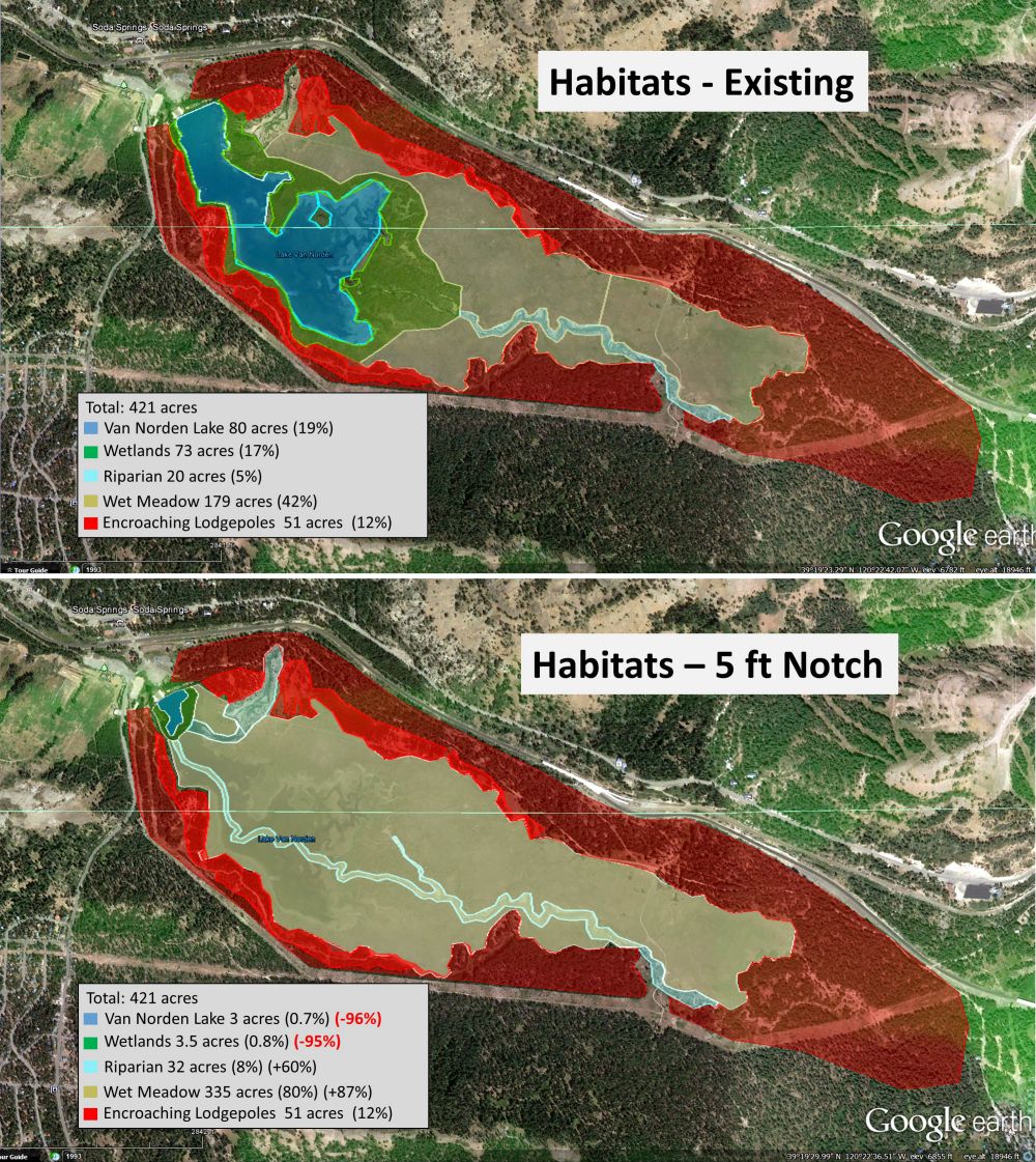
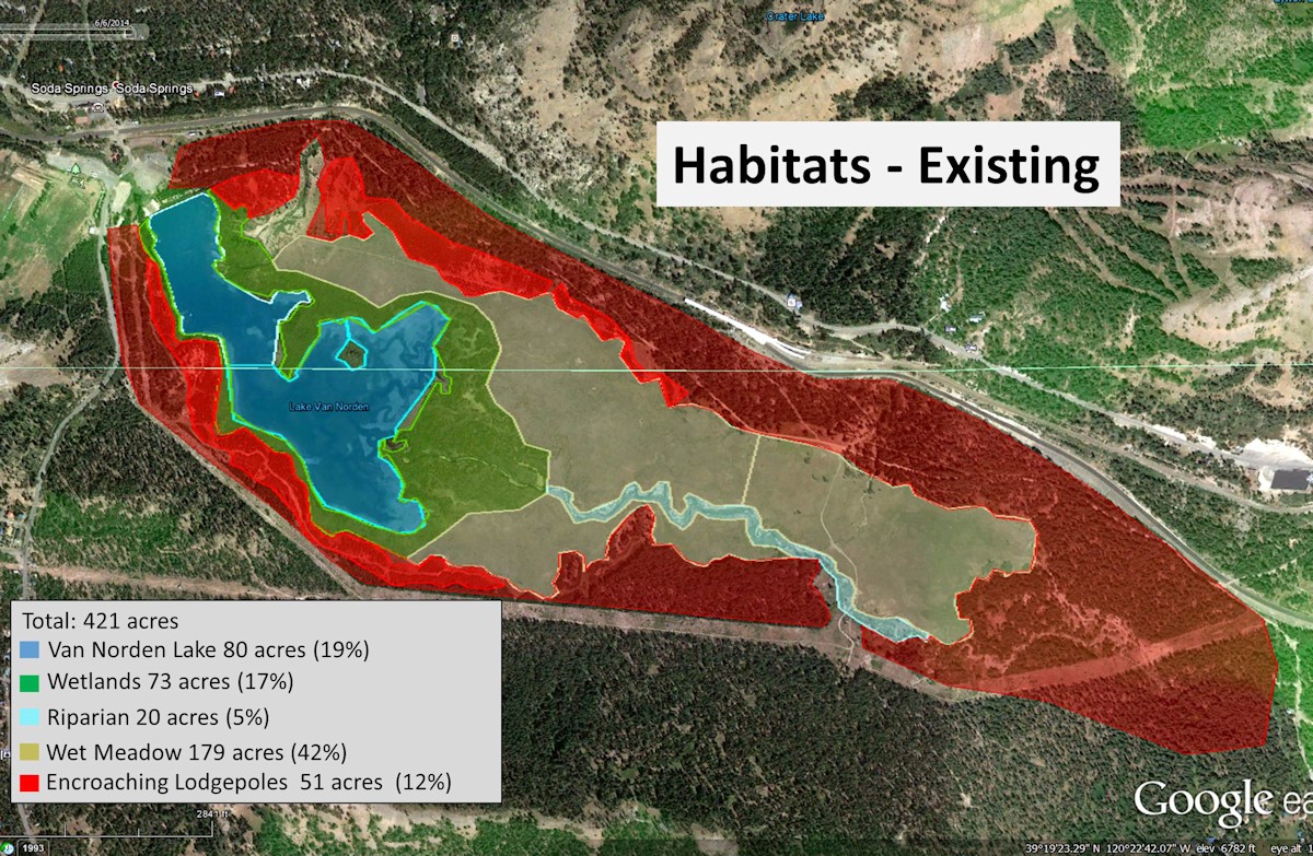
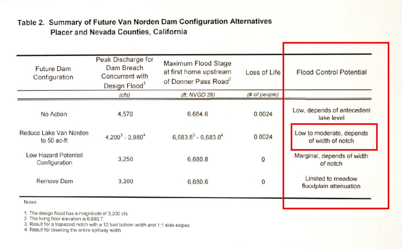
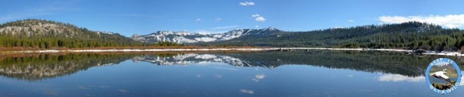
And that is point of this article. The Yuba river floods periodically, and when it does it poses a significant flood hazard. What this report touches on but fails to stress is that the Van Norden dam provides significant hazard prevention in the form of flood control. As shown in the last column of Table 2 of the report, the dam provides flood control potential except in the cases of reducing the lake to 5 acre-ft or removing the dam completely. And as the report clearly states, if the lake is left at 50 acre-ft it can provide moderate flood control that will serve to mitigate rather than increase the hazard of downstream flooding. The flood control effects are not seen in this type of report because the effects occur upstream of the dam. Attenuation of the storm surge by the dam would mean that in order to attain the flow rates for the Design Flood described here, the severity of the storm would have to be higher (something that would occur even less often), or in more practical terms, the same severity storm would cause less damage due to surge attenuation.

hydraulicevaluationtable2

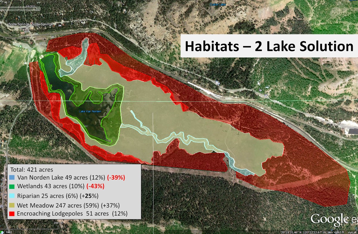
If public safety were really the issue for the Forest Service accepting Van Norden Dam then it would seem prudent for them to accept the dam. In fact they would be performing a public service by providing a form of flood control for the Summit Valley. The fact that they continue to oppose the dam in spite of the positive benefits to public safety and also the environmental benefits of preserving bio-diverse lake and wetland habitat in the valley makes one wonder what is their real motivation for their opposition to the dam? This is a question we think everyone should be asking the Forest Service.
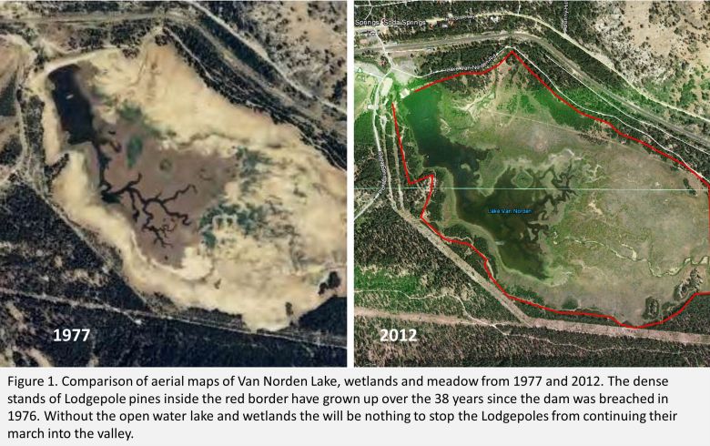
 

Posted in Uncategorized | 1 Comment

Donner Summit Valley Habitats

We have spent a lot of time on this site extolling the virtues of the lake and wetland habitats that Van Norden Lake provide. You can find out more about the value of wetlands from the large body of literature available on the internet. In this post let’s discuss the nitty-gritty of what will happen to those habitats if Truckee Donner Land Trust proceeds with their plan to drain the lake.

 Figure 1. Summit Valley existing habitats.


Figure 1. Summit Valley existing habitats.

The existing habitats in the Summit Valley are shown mapped in Figure 1.  As you can see the lake now covers 80 acres at the west end of the valley. Surrounding the lake is a band of wetlands that covers an additional 73 acres. There is no mistaking open water lake habitat. Wetlands, however are not as easily recognized. Let’s use the definition used by the Army Corps of Engineers and quoted in the U.S. Forest Service manual on Forested Wetlands

The term “wetlands” means those areas that are inundated or saturated by surface or ground water at a frequency and duration sufficient to support, and that under normal circumstances do support, a prevalence of vegetation typically adapted for life in saturated soil conditions. Wetlands generally include swamps, marshes, bogs, and similar areas.

Corps of Engineers Wetlands Delineation Manual (U.S. Army Corps of Engineers 1987)

Anyone that has ever tramped around Lake Van Norden in spring and early summer can attest the to presence of the wetlands around the lake. It is in fact the presence of the aquatic vegetation that makes the habitat a rich breeding ground for waterfowl, shorebirds, amphibians and fish. Note also that there are currently 179 acres of existing wet meadow habitat that is thriving in the valley

Summit Valley - Habitat changes6-6-14-working2


Figure 2. Summit Valley habitats after notching dam 5 ft lower

Now let’s consider the various scenarios that could affect the lake and wetland habitat in the valley. First let’s consider the most drastic change, TDLT’s plan to notch the dam 5 ft and drain the lake and wetlands. The resulting habitat map for this course of action is shown in Figure 2. This move effectively removes the lake and wetland habitats from the Summit Valley and all of the fauna and flora that these habitats support. The wet meadow habitat will expand of course, but the net change will be a large loss of bio-diversity in the valley.

Preserving Habitat

There is no feasible scenario that would preserve all the lake and wetland habitat. However, there are two scenarios that can preserve enough of these habitats to sustain some of the existing bio-diversity. In Figure 3 the “bare minimum” preservation scenario is shown for notching the dam by 2.2 ft to maintain 50 acre-ft of water in the existing lake.

Summit Valley - Habitat changes6-6-14-working3


Figure 3. Summit Valley habitats after notching dam 2.2 ft lower

This bare minimum will remove almost two thirds of the lake and wetland habitat, but the remaining third would still provide enough lake and wetlands to retain much of the fauna and flora to sustain the bio-diversity in the valley. This scenario would cost the same as the more drastic 5 ft notching of the dam and would require no additional funds.

The optimum solution for preserving lake and wetland habitat in the Summit Valley is to maintain water in the back bay area of the lake. There is a two lake scenario in which a low impact weir could be constructed that would maintain 50 acre-ft of open water in the back bay area. The resulting habitats are shown in Figure 4.

Summit Valley - Habitat changes6-6-14-working4


Figure 4. Summit Valley habitats with the 2 lake solution

This is the only scenario that preserves a large portion of the unique shallow water/wetland habitat in the back bay area that provides ideal habitat for breeding grounds for water fowl, shore birds and amphibians. This scenario would require the construction of the new weir which would be an added expense (probably in the $500-800 K range). The additional funding that would be required however only represents a small percentage of the overall cost of the property and government grants and loans for preserving wetland habitat could offset the costs.

We of course would like to see the two lake solution implemented to maximize habitat preservation. Barring that we believe that the 2.2 ft notching of the dam would truly be the bare minimum that would still retain the bio-diversity of the Summit Valley.

Posted in Uncategorized | 1 Comment

Mystery Solved – Anatomy of a news cast

Many people that have contacted us ask the question I will paraphrase here: “Why, after 38 years when PG&E breached the dam and it was dropped from the jurisdiction of the State, has the lake become an issue. Why can’t people just leave it alone?” We knew that the current hoopla started in the summer of 2011 when the Department of Safety of Dams (DSOD) came out and inspected the dam and put it back under their jurisdiction because it was larger than 50 acre-ft of water. We also heard that the State was responding to a request from Nevada County Emergency Services. What we didn’t know was the mystery of what prompted that request.

This week I was doing some Googling research on the Van Norden Dam and I came across the following newscast from  Channel 10 news in Reno in June of 2011. As you will see, this solved the mystery.

http://archive.news10.net/news/local/article/143947/2/Sierra-dam-cracks-worries-residents

PRETTY SCARY, huh?

I know what many of you might be thinking after watching this, “Maybe the dam is a danger!” Before you decide that the sky is falling, let’s just take a look at the facts surrounding the events and what actually was going on with the dam.

As anyone who was up here in the winter of 2011 knows, it was and epic snow year. It was rated in the top 5 snowfalls in the area which is saying a lot. The run off that year was also huge. One might think that the added flow intensity could have caused the crack in the front of the spillway. But let’s take a look at the dam during the runoff just a year before (a relatively normal year) in Figure 1.

Figure 1. Van Norden spillway on June 15, 2010

Figure 1. Van Norden spillway on June 15, 2010

Remember the spillway was 35 years old in 2011 and had very little maintenance. As shown in Figure 1, even in 2010 you could see a crack had developed during that time on the front of the spillway and water was escaping from the north front side of the spillway. In 2012 when the crack was repaired by Holdredge & Kull, they discovered that the crack had allowed water to enter under the front of the spillway and create a lateral void that channeled the water out the north front side of the spillway. In 2011, the heavy melt flow was diverted into the void channel where the added pressure caused the expanded crack that you see in the newscast.

While dramatic, the diverted flow in 2011 did not really pose a threat to the dam as the “untrained” newscasters implied. The crack in the dam was localized to the front north side of the spillway. You can see the location of the crack in the overhead view of the dam in Figure 2.

Figure 2. Overhead sat map of Van Norden Dam spillway

Figure 2. Overhead sat map of Van Norden Dam spillway

Of course, this is not a view that was available to the news crew that was shooting the 2011 story or to Mr Burton who first reported it to Channel 10. Even if the entire front north side of the spillway had failed, there was still almost 100 ft of dam behind it. Remember, this dam was originally built to hold over 50 times the water that it does now and 100 times the amount of a 50 acre-ft lake. This is why Mr Ferrera from Nevada County Emergency Services stated that he did not think the dam was a threat.

Now I am not trying to say that the dam does not need work. The episode in 2011 made this quite clear. In fact, in the summer of 2012, Holdredge and Kull repaired the crack and void to satisfy the concerns of the state and county. Even that repair was just considered temporary. Rebuilding the spillway has always been in the plan to fix the dam. No matter which plan is executed, a 2.2 ft notch to leave 50 acre-ft of lake or a 5 ft notch that will drain the lake, the spillway will be rebuilt to avoid further leakage problems in the foreseeable future.

The mystery however, is solved.


Posted in Uncategorized | Leave a comment