- Distance: 3.6 miles roundtrip to Donner peak – 5 miles roundtrip to Mount Judah
- Max elevation: 7988ft @ Donner Peak – 8209 @ Mt Judah
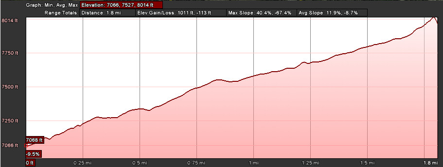
- Elevation gain: 1011 ft to Donner peak – 1143 ft to Mount Judah
- Difficulty: Moderate (trails are rocky in places)
- Start: Trailhead off of Old Donner Summit Rd near Lake Mary
- Activities: Hike
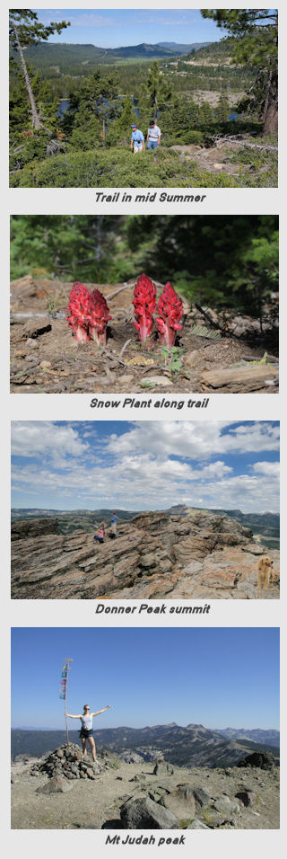
Donner Peak (39°18’32.75″N, 120°18’44.01″W), the namesake for the area is not the highest one in the area nor the most prominent. It does however afford spectacular views of the pass, Donner Lake and its sister peak, Mount Judah (39°17’54.74″N, 120°18’54.83″W). With regard to Mt Judah, this guide describes the trail to Donner Peak and also includes an optional loop out to Mt Judah. The trail is a part of the Pacific Crest Trail (PCT) that follows the crest of the Sierras. Hikes can be done to either peak of if you are feeling strong both peaks can be topped in a long loop. For those that are really out to burn their legs, the loop out to Judah can be stretched out to historic Roller Pass (see section in California Trail listing in Wikipedia). In early summer the area abound with wildflowers including Mariposa Lily, Columbine and even an occasional Snow Plant in the shadier areas.
The trailhead is located on the Old Donner Pass road near Lake Mary. Take the Sugar Bowl Rd turn off toward Judah Lodge at Sugar Bowl and turn left on the first road. There are parking spots all along the road all the way up to the Sugar Bowl Academy. The trailhead is well marked. Unlike many trails in the area, this one starts out with the most difficult section, a series of rocky switchbacks. This section can be tricky the late spring and early summer when the abundant water makes the rocks very slippery. Caution is advised. Once the trail reaches the top of the switchbacks it straightens out into a long winding gentle uphill climb to the south through coniferous forest on the west side of the ridge. There are great views of Van Norden Meadow and Mt Disney.
Approximately one mile up the trail there is a junction of the trails to Donner Peak and Mt Judah. The trails are not marked, but the open area is the first Sugarbowl ski run that the trail crosses. The loop out to Mt Judah is discussed below, but to proceed to Donner Peak make a sharp left turn here back to the north and follow the trail back through the forest. Continue up the trail for about a quarter of a mile to an open area and bear right on the trail to the west. The trail merges with an old logging road and continues up to the rocky approach to Donner Peak. Scramble up the rocks to the top of the peak.
For those choosing the Judah loop at the trail junction, proceed right on the trail and continue to the south through the coniferous forest on the winding trail. After about a mile of easy climbing through the forest the trail turns east and ascends up through the trees to the summit of Mt Judah. After enjoying the 360 degree views, proceed north as the trail descends down the ridge line and eventually reunites with the Donner Peak trail. Turning left on here will return down the mountain to the trailhead. Turning right and proceeding for a short climb will come out on Donner Peak. Let your legs be your guide.
Donner Summit – elevation profile (one way)
 Judah Loop – elevation profile (one way)


Nice, I love the fir/pine forest and woodland up there.