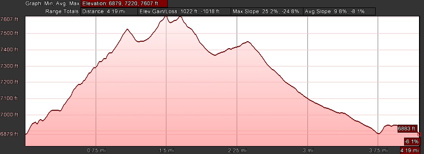
- Distance: 4.2 miles roundtrip
- Elevation gain: 1022 ft
- Maximum elevation: 7607 ft
- Difficulty: Moderate
- Start: Trailhead across from Ice Lakes Lodge
- Activities: Hike
Razorback Ridge is a steep ridge that stretches from Rowton Peak to Crow’s Nest and affords spectacular views of the North Fork river basin. The trail is a loop that begins at the Hoelter-Hall trailhead near the end of the paved Soda Springs Rd across from the Ice Lakes Lodge. It can be done in either direction and for this guide the hike will be described in the counter clockwise direction.
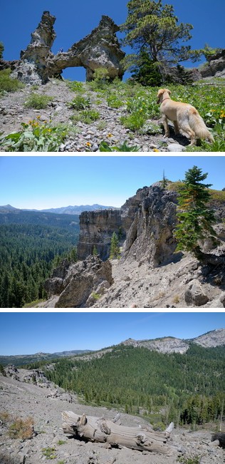
Start hiking south on the Tiny Tim ski trail and follow it up to a small meadow where in early summer Camas Lilies grow. Follow the ski trail straight across the meadow. There is a ski trail sign in the middle of the meadow that says this is Sterling Canyon trail, but the name was changed to Bogus Basin trail in 2012. At the end of the meadow the trail turns sharply to the left and climbs steeply up to the west end of Razorback ridge. At this point you can take the steeper road/ski trail the less steep meandering Rim Trail which both come out at the same place. There are great views of Serene Lakes looking out to the north. At this point the trail bears to the right and after about 500 ft there is a faint trail on the right that climbs up to the edge of the ridge. Walk south along the edge of the ridge that has spectacular views out into Serena Gorge and the North Fork basin. Make sure you keep your eyes on the rock formations on the right side of the trail. There is a wonderful natural bridge formation on the west face of the bride that should not be missed. Continue up the trail along the ridge until it reaches the top at Rowton Peak. You may notice a black cable running along the trail up the ridge. This was the transmission line from an old TV antennae that once stood on Rowton Peak to feed a signal down to Serene Lakes. There is a comfortable rock to sit on at the peak and take in the vista that sweeps from Crow’s Nest at Sugar Bowl in the east to Devil’s Peak in the west.
Razorback Ridge stretches out to the east and the trail climbs up and down along the peak of the ridge. The south edge of the ridge drops off precipitously as erosion exposed the ancient geology of lava and mud flows in tall pinnacles and hoodoos of basalt and conglomerate rock formations. Look for the twisted trunks of Mountain Juniper trees that grow along the stark ridge line. On each side of the trail wildflowers grow in profusion during early and mid summer. Early in the summer the purple flowers of Pink Star Onion grow along the ridgeline and later Mariposa Lilies and Mule’s Ear florish.
The trail follows the ridgeline for a little over a mile from Rowton Peak and then turns left at two large Jeffery Pines and heads back down towards Serene Lakes. Unfortunately, it is easy to get off trail on the way back because there many trails that wander back down to the lakes. The trick is to bear to the left onto the Claim Jumper ski trail for the most direct route back to the trail head. If you miss it don’t worry too much. All the trails end up at Soda Springs road where it’s easy to walk back over to the trailhead. If you do get onto the Claim Jumper trail follow it as it winds through the forest until it runs into the Reindeer ski trail which goes along the east side of Serene Lakes and ends up at the trailhead.