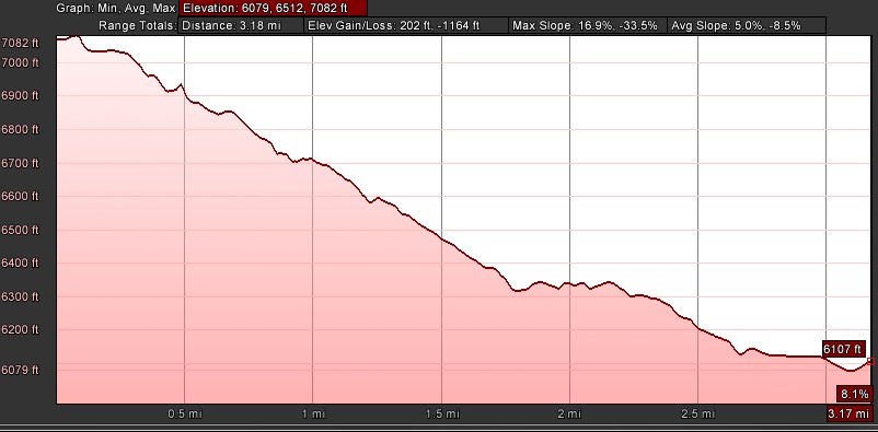
- Distance: 3.18 miles one way
- Elevation gain/loss: 206/-1169 ft
- Maximum elevation: 7082 ft
- Difficulty: Moderate (rocky sections of trail)
- Start: PCT trailhead at Donner Summit
- Activities: Hike
(Last update 1/3/13) Donner Summit is considered one of the most historic areas of California. It has always been a wildlife corridor through the Sierras and was used by native Americans in prehistoric times to transverse the mountains. The first transcontinental railway to join the United States was built in the mid 1800s through the summit and was followed by the first transcontinental highway in the early 1900s, the Lincoln Highway (dedicated to Abraham Lincoln). The highway through Donner Pass was rerouted later to the current Highway 40 and the original path of the highway now remains as a trail down from the summit almost to Donner Lake in Summit Canyon. In 2011 the Truckee-Donner Land Trust purchased the Summit Canyon area at the foot of the pass so that now the entire pass area is open space. The Old Lincoln Highway trail is now a great hike that winds down through the historic Donner Pass area.
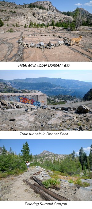
While this trail can be hiked in either direction, starting at the PCT trailhead at the top of the trail and hiking down is certainly easier and parking a car at Summit Canyon trailhead to set up a car shuttle makes the hike a pleasant down hill walk. This hike can also be started at the east entrance to Tunnel 6 in the parking lot across from Donner Ski Ranch. The walk through the tunnel is dark and can also be pretty wet in the spring and early summer. This guide will describe the start from the PCT trailhead. At the trailhead follow the trail through the willows to the east towards the pass instead of following the PCT to the south. Look for the historical marker for the Stephens-Murphy party on the right side of the trail about a quarter mile down the trail. After the marker the trail opens to the north and you can walk out on to the granite slabs to look over historic Tunnel #6 which was dug by the Chinese railroad workers. Returning to the trail continue down through the railroad underpass and then look out to the right to view the China wall built by the Chinese workers from fitted stones to support the railway bed. Follow the trail to the left as it winds down to the granite slabs of the canyon pass. Look for a circle of rocks on the slabs that outlines an old “horizontal billboard” for a Truckee hotel meant for early users of the highway. Head east down the pass over the granite slabs and as you approach the current road look for the petroglyphs made by early native Americans. Be careful not to walk on these delicate works of rock art. There is an excellent exhibit stand with great information about the petroglyphs.
In order to continue down the pass you will have to walk along highway 40 at this point for about 100 yards. Be careful here because cars and bikes come whizzing around the curve. If you are hiking with a dog you should leash it and be careful to keep young children away from the road. The trail picks up again at the parking lot for the snow shed climbing rocks. Follow the old road bed over the rocks as it winds down the pass until the trail separates into two routes, one on the north side and one on the south side of the river canyon. The route on the south side is the original path of the highway that crossed the Donner Creek over a bridge that washed out long ago. The foundations of the bridge are still standing.The route on the north side is a later path used by the highway.
Which path to take at this point is dependent upon the time of year. During the spring and early summer the snow melt fills Donner creek with water and the flow can be high enough that it could be dangerous to cross. The north route is the way to go at this time. As summer progresses the water flow lessens until the stream bed is completely dry and can be easily crossed. The south path is the original route of the highway and is the more scenic route. After crossing the creek follow the trail down into the forest of Summit Canyon. Keep an eye out for a rock along the right side of the trail with an ad for the TAMRAK inn. At the bottom of the trail there is a side trail that goes up to a picnic table on the ridge that gives a great view of Donner lake and is a good place for a snack.
To finish the hike retrace the trail back down from the picnic table on the ridge back to the main trail and then continue through the forest and past the old beaver ponds to cross Donner Creek one last time over a rickety bridge to the Summit Canyon trailhead. If you have staged a car here then your trek is done. If not, you can retrace your steps back up the trail.
Elevation profile for one way


Please do not be fooled by the short distances. Start in the morning, early, say 9 o’clock. Plan on getting back late afternoon (this is if hiking both ways, i.e. 7 miles).This does not apply if you are an athlete in great shape. The trail is steep rocky and tiring.
Bring water. Snacks. Toilet paper. Mosquito dope. Sunglasses. Blister cloth (moleskin). Take your time. We found lots of mosquitoes!
Besides, it is not a contest. Frequent lunch and photo breaks are what makes an outdoor trip all the more fun. You could do it in half a day, or less, but this is not guaranteed for everyone who starts out.