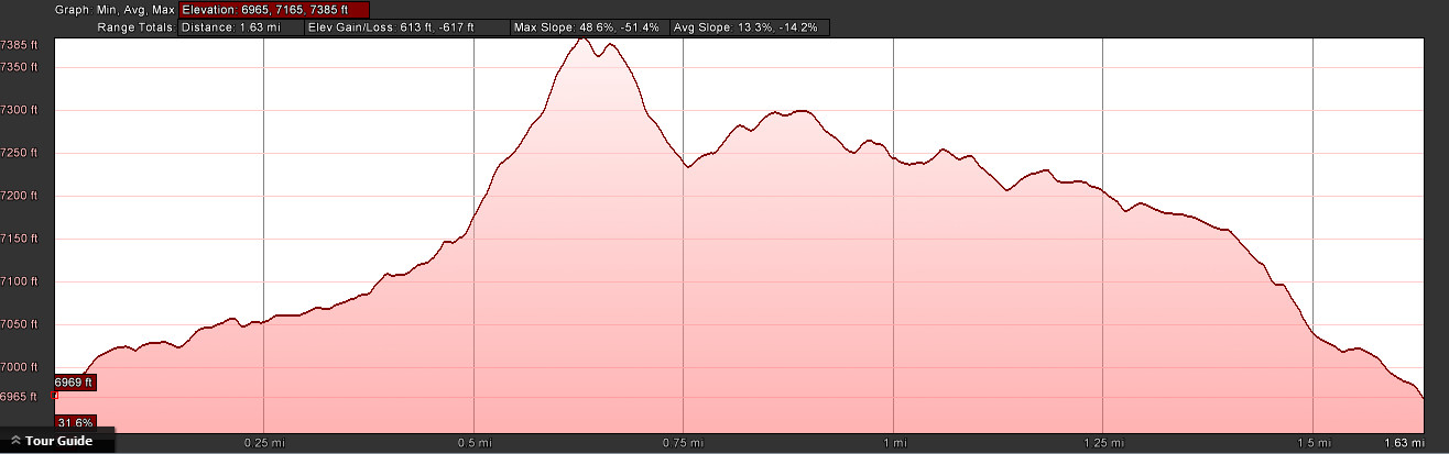
- Distance: 1.6 miles roundtrip
- Elevation gain: 531 ft
- Maximum elevation: 7394 ft
- Difficulty: Moderate (steep switchbacks & rock scrambling)
- Start: Trailhead in Donner Pass just above Rainbow Bridge
- Activities: Hike
George R Stewart Peak is that very prominent granite dome that you see as you look north while driving over the Rainbow Bridge in Donner Pass. The peak is named for the historian and novelist, George Ripley Stewart, who wrote extensively about the Donner Summit area.
The trailhead for this hike is a pullout along old Hwy 40 just above the Rainbow Bridge. It can be a little dicey getting to it on a busy summer weekend when there are many cars parked along the highway in this area. BE CAREFUL to keep your kids and/or dogs off the busy highway in this area.
Walk north up the gully for about 200 yards and bear right on to the Pacific Crest Trail. Follow the trail northeast over the granite rocks and then up the switchbacks that climb up to the top of the ridge. Turn to the right (east) off of the PCT and meander up the gully that approaches the dome of Stewart Peak. You will have to scramble up the granite slabs to reach the top of the dome where you can enjoy the wonderful views of Donner Pass.
Head back down the way you came until you reach the PCT again. Proceed north west down the PCT for about 50 yards and then bear left up the granite slabs. Now getting to the Catfish Pond is the tricky part. I can’t tell you how many people have told me that they couldn’t find the pond. There is no marked trail over the granite slabs but what you want to do is first go west for about 50 yards up the slabs and then turn south and scramble down through the rocks until you reach the pond. The mistake most people make is going too far west and running into Lake Angela. The catfish pond is about 200 yards east of Lake Angela. Once you get to the Catfish pond you may be able to see the Bullhead Catfish that inhabit the lake (allegedly stocked by Chinese railroad workers). On a still day they will be right at the surface. You should also make sure you go up to the north rim of the pond to see the “dragon” that lives in the roots of an old pine.
To finish the loop head south from the pond until you hit a trail in a rocky gully that heads back towards the east. Be sure to keep an eye out for the trail marker for the Stephens, Townsend Murphy party. After a scramble down the gully you will join up with the PCT again and you retrace your steps south down the gully back to the trailhead at the road.
Elevation Profile – round trip