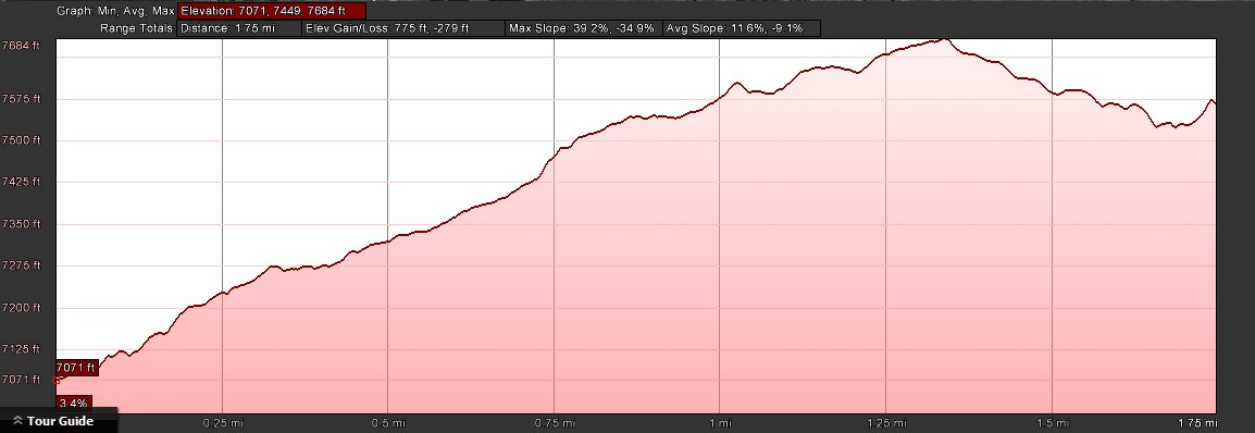
- Distance: 3.5 miles roundtrip
- Max elevation: 7071 ft
- Elevation gain: 789 ft
- Difficulty: Moderate (trails are rocky in places)
- Start: PCT trailhead off of Old Donner Summit Rd near Lake Mary
- Best time: Middle to late summer (after mosquito season)
- Activities: Hike
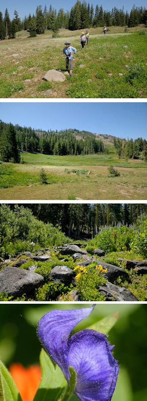
The South Yuba River winds through the Donner Summit Valley and drains almost 3000 acres of watershed. There is a natural spring that seeps out of Mt Judah just below Roller Pass, that is the headwaters for the river ( 39°17’44.46″N, 120°19’21.15″W). The high alpine meadow where the spring emerges can be reached from the Pacific Crest Trail (PCT) that climbs Mt Judah (see Donner/Judah Peak trail). The meadow is a beautiful garden of mountain wildflowers that lasts throughout the summer due to the constant source of flowing water. It is well worth the walk.
The trailhead is located on the Old Donner Summit road near Lake Mary. Take the Sugar Bowl Rd turn off from Donner Pass Rd toward Judah Lodge at Sugar Bowl and turn left on the first road, Old Donner Summit Rd. There are parking spots all along the road all the way up to the Sugar Bowl Academy. The trailhead is well marked. Unlike many trails in the area, this one starts out with the most difficult section, a series of rocky switchbacks. This section can be tricky in the late spring and early summer when the abundant water makes the rocks very slippery. Caution is advised. Once the trail reaches the top of the switchbacks it straightens out into a long winding gentle uphill climb to the south through coniferous forest on the west side of the ridge. Look for Penstemon and Mariposa Lilies in mid summer. There are great views of Van Norden Meadow and Mt Disney.
Approximately one mile up the trail there is a junction of the trails to Donner Peak and Mt Judah. The trails are not marked, but the open area is the first Sugar Bowl ski run that the trail crosses (the Tunnel 41 run). Continue straight on the Judah loop trail to the south through the coniferous forest on the winding trail. Now comes the tricky part of the hike because in order to reach the meadow it is necessary to leave the PCT and go cross country. The trail goes past the the top of the Jerome ski lift that can be seen on the right. At this point the trails bears slightly to the left as it heads up towards Mt Judah. Follow it for about 20 yards to where the forest opens up to a clear spot on the right ( 39°18’3.84″N, 120°19’17.67″W). Leave the PCT at this point and head due south following the cleared area through the forest. Continue south through the open areas along the left edge of the forest until you come to the large meadow of green willows just below Roller Pass. This will be pretty wet early in the summer. Work your way up the stream in the middle of the meadow (the Yuba River) until you reach what looks like a flat rock outcropping decorated with wildflowers where the spring emerges from the rocks. The outcropping is actually a concrete trough, probably constructed originally to water livestock. The wildflowers that flourish in the area will vary depending on what time of the summer you visit. Look for the lovely blue Monk’s Hood that loves the wet meadow soil. It would be hard to find a more beautiful spot to have lunch and enjoy the alpine beauty. After lunch you can return by retracing your steps down the mountain.
Elevation profile (one way) Click for larger view