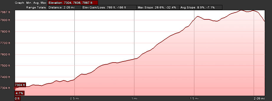
- Distance: 4.2 miles roundtrip (from SnoPark)
- Elevation gain: 769 ft
- Maximum elevation: 7987 ft
- Difficulty: Moderate
- Start: End of paved road on north side of Boreal offramp on Hwy 80
- Activities: Hike, ski
The trail to Peter Grubb hut (39°21’57.97″N, 120°21’57.21″W) is a very popular route along the Pacific Crest Trail (PCT) to the historic hut. The hut is maintained by the Sierra Club and is a favorite destination for backpackers and cross country skiers. Reservations to stay at the hut can be made through the Sierra Club. The trail winds along the west ridge approach to Castle peak and the views of the area are spectacular.
The trailhead is located on the north side of the offramp for Boreal ski resort on Hwy 80. Where the trail starts depends on the time of the year and how much of the unpaved road is accessible. In the winter the trail starts right at the end o the road on the north side of the Boreal off ramp. This road is only a loading area and parking is only available at the SnoPark at the end of Bunny Hill Rd on the south side of Hwy 80 (a SnoPark pass is required during the winter and can be purchased at many locations) . Parking in the winter on holidays and weekends can be challenging with only limited parking in the SnoPark on Bunny Hill Dr near Boreal. In the summer when the snow is clear and the road is dry, it is possible to drive almost a mile up the unpaved road (4 wheel drive is usually not necessary unless the road is pretty wet). The farther you drive up the road the shorter the hike becomes. This guide will describe the trail from the trailhead at the start of the unpaved road.
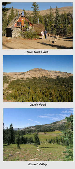
For the first mile the trail is the unpaved road and is easy to follow. The road is wet early in the summer but drys out by the end of June most years. About a half mile up the road, there is a road branching to the right into the Castle Peak bowl area. There are beautiful meadows of wild flowers in the area during the summer. At the end of the road the walking trail bears to the left up a moderately steep climb up to the top of the rocky ridge. At the top of the ridge there is an open area with a great view of Castle Peak. The trail forks here with the trail to right going up to Castle Peak summit (a strenuous climb to over 9000 ft that can be attempted for the really adventurous) and the trail to the left goes on to Round Valley and Peter Grubb. The left trail continues along the west side of the ridge and climbs up toward Round Valley and the hut. As the trail nears Round Valley it winds down into the valley and past Peter Grubb hut nestled in the trees. It’s a good idea to pay attention at this point because it is easy while appreciating the scenery to walk past the hut. The hut itself is a rustic building with a kitchen, loft and dining room and an all-weather outhouse. In the winter skiers spending the night can expect to be quite close to some of the smaller wildlife of the area.
Round Valley is a beautiful bowl filled with snow in the winter and wildflowers in the summer. Farther up the trail is Sand Ridge Lake where many backpackers go for the night. To return to the trailhead just retrace your steps back down the trail.
Warning: The Castle Peak area is prone to avalanches when snowfall is heavy. It is probably best to consult the Sierra Avalanche Center before attempting to ski in if there has been heavy snowfall in the area.
Elevation profile – one way

