 (last updated 8/24/15)
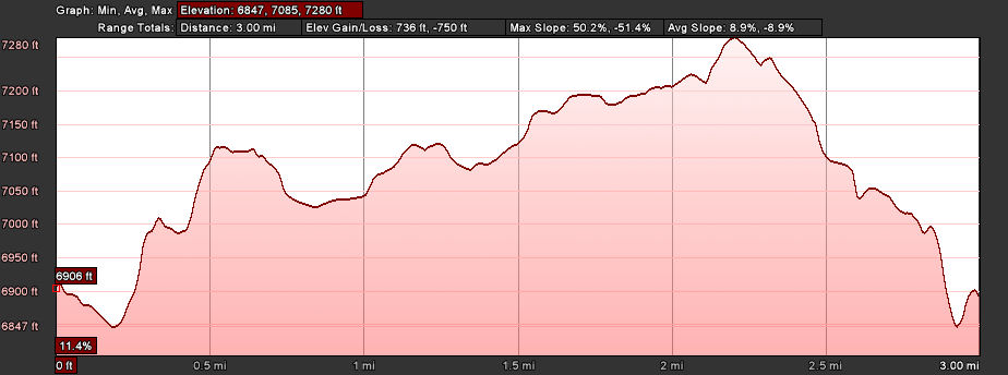
- Distance: 3.0 miles roundtrip
- Elevation gain: 736 ft
- Maximum elevation: 7280 ft
- Difficulty: Moderate (steep climb at top)
- Start: Rainbow bridge overlook
- Activities: Hike
Donner Pass is rich in human history from prehistoric times to today. The pass has served as a route through the Sierras for thousands of years and was used as a migratory trail long before the Donner party’s fateful attempt. It became a main artery of modern travel in California when the transcontinental railroad was completed and today Interstate 80 is the busiest highway across the Sierras.
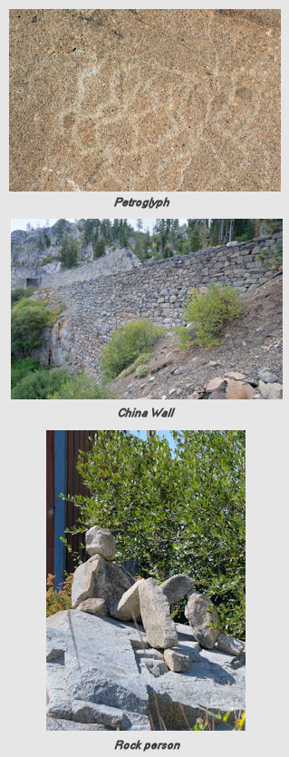
Historical artifacts from past human ventures remain in the pass and can be observed today in a relatively short hike. A convenient place to start the hike is at the Rainbow bridge overlook. After parking and taking in the view of Donner Lake, carefully cross Donner Pass Rd and walk down to the entrance to the petroglyph area on large granite slabs. There is an excellent exhibit at the petroglyphs and carefully wandering over the slabs will reveal many of the ancient works of art. Climb up the slabs to the west and look for the circle of stones around an old ad for a Truckee hotel painted on the slabs. Continue to the west and follow the trail through the bushes that turns left up the remnants of the old Dutch Flat Donner Lake Wagon Road. Follow it to the top where you get a good view of the China Wall. The wall was constructed by the Chinese railroad workers and is constructed of fitted stones with no mortar. Continue through the underpass of the old railroad bed and then turn left up the ramp to the entrance to Tunnel 7. At this point the old roadbed for the railroad that runs through the man made snow sheds can be observed. When the new tunnel under Mt Judah was constructed, the tracks and railroad ties were removed. From this vantage point remnants of the old Dutch Flat-Donner Lake wagon road that was built in 1863 can be seen.
To continue the hike walk to the west in the old roadbed through the snow shed and proceed through Tunnel 6, the longest tunnel, carved out of the rock by the Chinese workers after two years of hard labor. It’s a good idea to bring a strong flashlight because the tunnel is dark and littered with large rocks and water puddles. About half way through the tunnel shine the light up to the ceiling of the tunnel. The old access shaft going to the surface above the tunnel can be observed. Continue to the end of the tunnel that comes out in the parking area across from Donner Ski Ranch. Continue walking west in the parking lot and then go left up the dirt road to Old Donner Summit Rd. Turn right on the road and go down about 30-40 yards and then cross the road and explore the area south of the road. This is the site of the original Summit Hotel and you will see old foundations and lots of glass and crockery relics in the dirt. Once you are done exploring head east on the road and cross the paved Sugar Bowl road and follow the road past the entrance to Mary lake and the PCT trailhead. You will come out in the parking lot of the Sugar Bowl Academy. Just behind the old maintenace shed on the left you will see the metal covered cement cap on top of the vertical access shaft that was used to dig Tunnel 6. Proceed carefully across Old Highway 40 and carefully walk west keeping an eye out for cars.
Continue walking west towards Donner Ski Ranch and keep an eye out on the south side of the road for the famous rock people that inhabit this area. Turn right into the first trail entrance (you will again be on the PCT). Climb up the trail to the north east toward Lake Angela around the back side of Mt Stephens. Things get a little dicey up on these granite slabs because there are many trails that criss-cross through the area. If you bear towards the right you may run into the marker for the Stephens-Townsend-Murphy party that came through the pass in 1844. The marker was erected by the Trails West organization and the location of this marker is controversial since there is also a maker on the south side of the pass for the same route.
From this point on the trail gets very sketchy. You can continue east down the gully past the marker and then south back to the road. If you are adventurous you can head back north and scale the granite slabs in search of the Catfish pond. The approach to the Catfish pond can be hard to find so you might have to do a little zig-zagging. The story goes that the small pond was stocked with catfish by the railroad workers who used them for food. If you are there at the right time of day you might see them swimming near the surface. If you are intrepid you can continue to scale the slabs heading west until you cross the PCT below the top of George L Stewart peak. Head south and descend the switchback trails down the base of Mt Stephens at Donner Pass Rd. Walk down the road and carefully cross the Rainbow Bridge back to the parking area at the overlook.
For more information on Doner Summit history visit the Donner Summit Historical Society
Elevation profiles – round trip


The old pioneer trail also known as the Donner Lake Wagon Rd is now open to the public from the base of east side of the pass on Hwy 40 (about 1/3rd of a mile after you leave Donner Lake heading west) to the summit. There is a small parking area and signage on the left hand side of Hwy 40 in the forest. Its a short walk to the summit…maybe 2 miles with some scrambling over rocks on the upper third. Enjoy!
The train tunnels are now closed to use by everyone, by southern Pacfic. See gate at beginning of the tunnels.
Laura is correct about the new gate at the west entrance to Tunnerl 6. Union Pacific put them up in the summer of 2012 after there was an incident in which a pickup truck drove down through the sheds and ended up getting stuck on the active UP tracks down near Schallenburger Ridge. Now I would never encourage anyone to break the law, but it is my experience up here that most no trespassing signs are posted more for liability reasons than a realistic expectation that the signs will prevent people from entering the property. The gate is constructed in a way that it precludes entry by vehicles, but there is no impairment to entry by foot. From what I have observed since the gate went up, there has been no decrease in the foot traffict through tunnel 6. I leave the decision to enter the tunnel to you.