
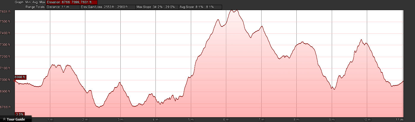
 Distance: 11 miles
- Elevation gain: 2577 ft
- Maximum elevation: 7600 ft
- Difficulty: Very strenuous
- Start: Summit Station Trailhead
- Activities: Hike, trail run
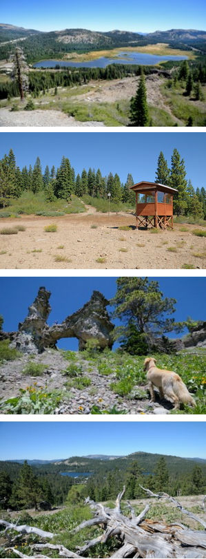
Most of the hikes described on this site are for the casual day hiker looking for a nice walk in the area. Every once in a while I get a request from a high level trail runner or hiker for “something a little harder” This trail is my answer to those high level athletes. The trail is in the spirit of other rim trails such as the Donner Lake Rim Trail and does a circumnavigation around Serene Lakes. The trail is actually a combination of existing ski trails and single track that make a complete circuit around the lakes. This trail is not really for mountain bikers due to steep rocky sections and trail restrictions implemented by the Truckee Donner Land Trust.
Trail Description
Since this trail is a large loop it can be started pretty much anywhere and done in either direction. For this description we will start at the Summit Station trailhead and do it in a counter clockwise direction. Once you leave the trailhead you head south along the Big Ben ski trail. This is a nice flat trail through newly thinned forest. When you reach the open area where the old rope tow tower still stands, head up the open slope where you run into the Castle Pass ski trail. It gets a little steeper as you climb up towards Palisade Peak. Turn left to follow the Castle pass trail which is pretty flat as in runs along the east side of Palisade Peak. Continue straight south on the Castle Pass trail past where it intersects with the Half Hitch ski trail (WARNING MOUNTAIN BIKERS – the trail over Castle Pass and out to Mariah Pt from this point has been restricted to hiking only by the Truckee Donner Land Trust). You are entering US Forest Service land at this point. Continue up the trail which will take you over Castle Pass and into the Palisade Creek watershed.
The trail plunges down for about 1/4 mile. Bear left on the trail until you come to a T and turn left onto the Hellman’s Way ski trail. The trail continues falling for the next 1/4 mile until you reach a beautiful alpine meadow where wildflowers abound in mid summer. The trail continues south across the meadow and then climbs steadily up the ridge for the next 1/4 mile. Continue south past the intersection with the Sterling canyon trail and up a couple of steep hills to the top of the ridge. Continue along the ridge until you pass the Hellman’s Warming hut. Follow the trail to the left that sweeps around into the Sterling Canyon ski trail (the trail to the right goes another mile out to Mariah Pt). Follow the Sterling Canyon trail for the next mile and half as it runs along the Serena Creek gorge. The trail goes past the leg burning Sunnyside hill trail and continues north to the bridge across Serena Creek and up to Soda Springs Rd.
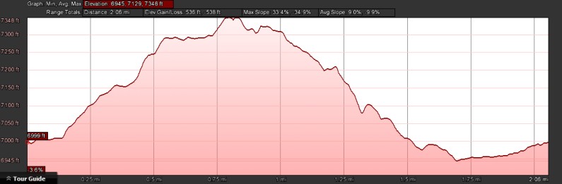
Continue south on the road for about 50 yards and then enter the Silverado Ski trail on the left. (This next bit is all up hill and will be alot of bike pushing for all but the strongest riders. I would suggest heading up Soda Springs Rd and taking the Tiny Tim trail to Bogus Basin and taking Bogus Basin to Forest Service ridge as a viable alternative) Follow the trail as it climbs steeply up to Tiny Tim Meadow where it meets up with the Bogus Basin ski trail. Turn right onto the Bogus Basin trail which again climbs steeply up towards Razorback Ridge. When you get to the top of the climb turn right off the Bogus Basin trail and on to the meandering single track trail that goes up to Rowton Peak. Follow the single track along the rocky ridge until it reaches Rowton Peak. Head east along the trail that goes along the top of the undulating Razorback Ridge. Continue along the ridgeline for about a mile and a quarter to the entrance of a trail to the north between two huge Western White Pines.
Follow the trail as it heads back down into the forest. Continue for about half a mile. It gets a little tricky here because you cross the Claim Jumper-Nose Dive ski trail before you pick up the Forest Service Ridge trail. Go past the Claim Jumper trail and continue west until you hit the intersection with the Forest Service Ridge trail (not marked). Turn left and head northeast on the trail that sweeps around to the west as it heads along Forest Service ridge. Continue on this trail as it dips and then climbs up the ridge. Head west along the ridge. At the west end of the ridge the trail gets very loose and BE CAREFUL on the steep treacherous downhill off of the ridge.
At the bottom of the ridge trail turn right onto the Switchback ski trail and follow it for a couple of hundred yards. Bear left on the trail until you reach Soda Springs Rd. Head across the road and follow the Interconnect ski trail along the north side of the Serene Lakes community. Just before you hit the parking lot for the Royal Gorge Summit Station turn right onto the Thor ski trail and start climbing up towards Beacon Hill. (This is not recommended for mountain bikers as the trail is very steep and the Beacon Hill ridge is very rocky). Follow the trail as it heads to the right up to the top of Beacon Hill. Turn left and follow the trail along the rocky ridge for about half a mile. Look for a faint downhill trail to the left and follow it down through the forest to the meadow at Royal Gorge ski resort. Continue through the meadow back to the Summit Station trailhead. and congratulation for completing the most difficult trail in the area.