
 Distance: 2 miles
- Elevation gain: 529 ft
- Maximum elevation: 7347 ft
- Difficulty: Strenuous – steep uphill and downhill sections
- Start: Summit Station Trailhead
- Activities: Hike
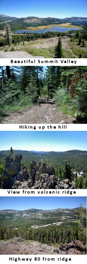
Beacon Hill is located on the north side of the Royal Gorge area ( 39°18’58.77″N, 120°23’10.61″W) and affords wonderful views of the Summit Valley, Palisade Creek basin and Serene Lakes. The hill got it’s name when aviation navigation beacons were installed at the top to guide early aircraft through the Sierras.The hill now serves as a ski hill for the Soda Springs Ski Resort during the winter season. The route is a loop which can be done in either direction, but I would recommend doing it in the counter clockwise direction. Although it is pretty short, this hike is listed as strenuous because of the steep trail to the top and the rocky descent from the ridge. This hike is best done in middle July after the snow melts. The land on the south side of the hill is owned by the Truckee Donner Land Trust (TDLT) and the top of the ridge is owned by the operators of the Soda Springs ski resort, Boreal Ridge corporation.
Trail Description
Best to begin this hike at the Summit Station trailhead maintained by the Truckee Donner Land Trust. Walk northeast across the Summit Station parking lot to the start of the Summit Connection ski trail at the east end of the parking lot. Bear to the left on the ascending Thor ski trail (not used anymore) and follow it as it winds up the south side of Beacon Hill. There are some nice older Red Firs along this trail. As you approach the steeper part of the hill bear right up the ski track/cat track to the go straight up the hill to the top of the ski hill. The view of the Summit Valley from the top is one of the best. You might want to walk out on the ridge to the east to get the full view of the valley. After admiring the view head west along the top of the ridge until you hit a couple of big old pines. There is a volcanic formation that juts out to the south and gives great views of the Serene Lakes basin. The lichen on the lahar formation is also very colorful.
Continue west along the rocky ridgeline and observe the expansive views of Castle and Basin Peaks. Look for Pink Star Onion and Mariposa Lilies through early and middle summer. You may even see a few Kellogg’s Lewisia if you keep your eyes on the ground. Continue along the volcanic ridge for about a half mile until you come to a dip where a faint trail heads back down the south side of the ridge. Follow the trail which is the Mirkwood ski trail as it winds back east through the forest until you hit the open meadow. Summit station should come back into view and look for Meadow Penstemon and Lupine as you loop back to the trailhead through the meadow.![]()