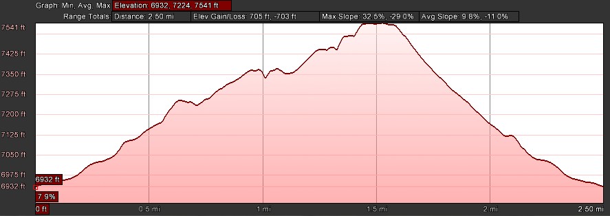
- Distance: 2.5 miles roundtrip
- Elevation gain: 705 ft
- Maximum elevation: 7541 ft
- Difficulty: Moderate
- Start: Trailhead at west end of Kilborn Dr in Serene Lakes
- Activities: Hike, ski (need Royal Gorge trail pass during season)
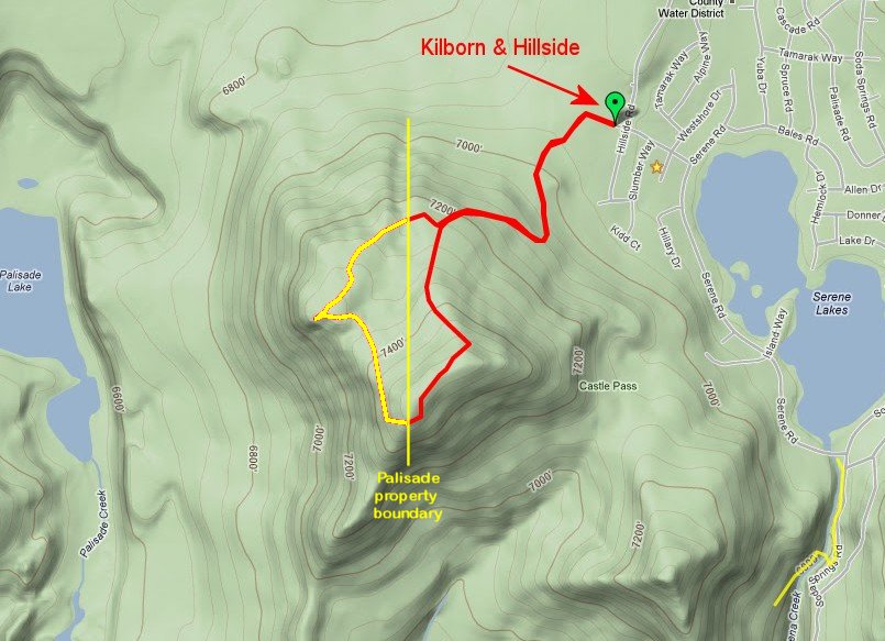
Palisade Peak ( 39°17’51.92″N, 120°23’54.45″W) on the west side of Serene Lakes is a great vantage point for views of the Royal Gorge area of the summit. The peak can be accessed from several points on the west side of Serene Lakes. This guide describes a route from a trailhead at the west end of Kilborn Dr in Serene Lakes. If you are skiing, you will need a trail pass from Royal Gorge resort during their open season.
WARNING: A portion of the trail that is shown on the map below is on private property owned by the Palisades. These owners are pretty hostile to sharing their property with anyone, so I have marked their property boundary and the portion of the trail that they own on the map in yellow. To avoid trespassing you will need to stay on the east side of the peak on the trail marked in red. All I can say is I would never encourage anyone to trespass on private property, even for the spectacular view from the west side of Palisade Peak.
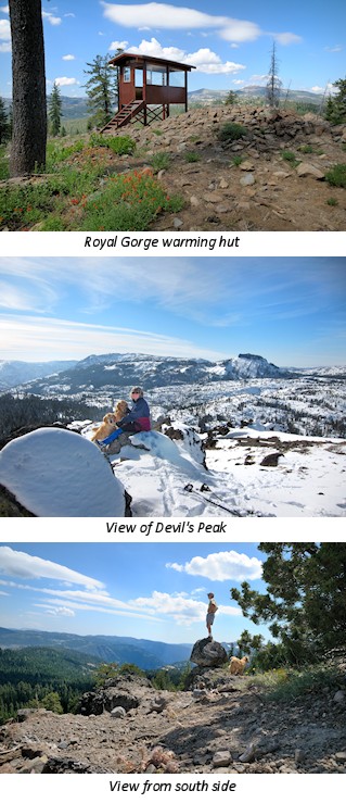
Follow the trail into the forest and after about 100 yards turn left onto the Big Ben ski trail. You might want to mark this intersection because it can be tricky to spot when coming back. The trail winds through a narrow meadow where there is an old ski tow. Follow the old tow line up the slope and bear left onto the Palisade ski trail. Continue south on the trail following the ski signs to Castle Pass. The trail starts the climb up to the peak as it turns to the west. Continue west on the trail past the intersection with the trail from Castle pass. This is the steepest part of the climb but is well worth it for the great view of Castle Peak from the ski warming hut. To avoid trespassing on private property you will have to turn south and bushwack up the east side of the peak to the top (stay on the red trail on the map). In winter the ski trail continues to the west behind the warming hut and winds through a grove of relatively old growth trees encrusted with Wolf Lichen. The trail is less defined at this point but is relatively easy to follow as it winds its way to the west side of the peak. The west side of the peak is a spectacular formation of volcanic pinnacles and the view overlooks the Palisades Basin and Devil’s Peak area
From the east side of the peak overlooking Serene lakes, you bushwack north back down through the littered forest for approximately a quarter of a mile until you cut the ski trail that you came up on. Retrace the route back to trailhead to finish the hike.
Click on map f0r an interactive Google map