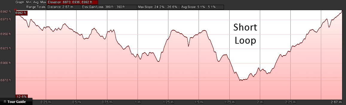
- Distance: short loop – 2.7 miles; long loop – 3.3 miles
- Elevation gain: short loop – 389 ft; long loop – 541 ft
- Maximum elevation: 6992 ft
- Difficulty: A nice easy walk on wide existing ski trails
- Start: Summit Station Trailhead
- Activities: Hike, mountain bike, xcountry ski at Royal Gorge resort
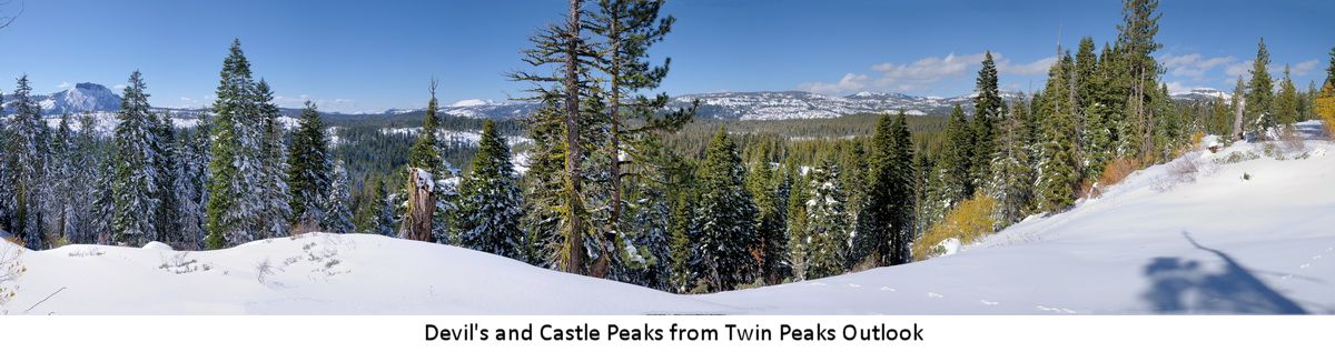
Lyle’s Lookout is located on the west side of the Royal Gorge area ( 39°18’9.16″N, 120°24’21.42″W) and affords wonderful views of Devil’s Peak and the Palisade Creek basin. The access trails are entirely on open space land owned by the Truckee Donner Land Trust (TDLT). The trails are all wide, well marked ski trails used by the Royal Gorge cross country ski resort in winter (ski trail names are shown on the map below). There are two different loops that can be done depending on how far you want to travel. This is an excellent hike for people that just want an easy walk with spectacular scenery. It is also a good trail for a warm day because there is plenty of shade along the trails. The loops can be done in either direction but I prefer the clockwise direction. Skiers will have to have a valid trail pass from the Royal Gorge ski resort during the cross country skiing season. However, before and after the season this can be an excellent back country ski. For mountain bikers, the James Joy trail has been designated as hiking only by the TDLT so you might want to use the parallel Big Ben Trail for that leg of the route.
Early in the season these trails can be wet from snow melt and they are also pretty buggy before July. Look for the bright red snow plants if you hike it early. Wildflowers abound from early July to September. After the middle of July you can’t miss the minty fragrance of the Penny Royal that covers the area. Look for signs of Black Bear (usually right in the middle of the trail) all summer. You may spot a Black-tailed deer or two and in July, you may see them with their fawns. American Martens also frequent this area, so keep an eye out for this sleek creature about the size of a big cat. Bobcat and even Mountain Lion are in the area, but dont’ worry, you will never see them.
Trail Description:This description is for the hike done in the clockwise direction. Much of the trail is marked with Royal Gorge ski trail signs and will be referred to in this description. This guide describes the start from the Summit Station trailhead at the end of Pahatsi road across from the Royal Gorge ski resort. Parking at the trail head is adequate even for a mid sized group.
Follow the nice wide trail south over to the cleared power line corridor. Proceed west for about 100 yards to the trail intersection and continue south along the James Joy trail. As you go you will notice that the forest has been recently thinned as part of the forest restoration project currently in progress by the TDLT. This forest consists primarily of Lodgepole Pines, Red Firs, and occasional Western White Pines. Continue on the trail until it intersects with several trails including the Killy’s Cruise trail. Proceed on the Killy’s Cruise trail to the west. This section of trail can be wet in the early summer. Look for orange Columbine in July along the many seasonal creeks that cross the trail. In August look for Alpine Lilies in the same areas. The many creeks make for many watering spots if you hiking with your dogs. Continue on this trail for a little over a quarter of a mile until the trail branches. Bear left to the Lyle’s Lookout trail that heads up to this scenic overlook. As you approach the lookout area, keep an eye out for the star shaped yellow flowers of the Pretty Face plant. Spend some time here looking out over the glacial scraped granite of the Palisade Creek basin and the impressive basalt monolith of Devil’s Peak. If you do this hike early in the day, you may be able to see the basalt columns in the direct morning sun shining on the peak. Make sure you also venture out to the north side of the lookout area. This area I call Twin Peaks Lookout because you can see both Devil’s Peak and Castle Peak, in 180° opposition to each other. If you are hiking in August, look for the purple fronds of Horsemint that grow in the tall grass in this area. This a true member of the mint family and has a wonderful fragrance. It was used by native Americans to flavor their food.
When you head back down from the lookout and return to the branch in the trail, this is the time to decide if you are doing the short or long loop. Be forewarned that if you choose the long loop, you will be descending another 200 ‘ down to the Palisade Creek basin and adding another .6 miles to your walk. If you are skiing, the Guillotine is steep and coming up the Little Dipper trail can be a bit of a slog. If you choose the short loop then proceed back along the Killy’s Cruise trail for about 100 yards and then bear left down the Crosscut trail until it intersects with the Gold Rush trail. Bear right on the Goldrush trail and continue east until it finally intersects with the Palisade trail. Follow the trail as it heads northwest back to the power lines and the trailhead.
If you choose the long loop, then turn left down the Guillotine ski trail. Warning to skiers, this trail is steep and when it is icy it can be pretty treacherous. Warning to mountain bikers, besides being a steep downhill this trail crosses through a ridge of tuff rock. This is very treacherous and frankly scary riding on a mountain bike. I wouldn’t recommend it. It is perfect for hiking. The rocky ridge is covered with pink and white Phlox in the early summer and the exfoliated tuff rock is almost musical as you walk over it. When the trail gets to the bottom follow it as it curves north and eventually cuts the Palisade trail. Turn right onto the Palisade trail and follow it over to the old rope tow lift clearing. Continue east up the Little Dipper trail until it connects with the Palisade trail at the power lines and then back to the trailhead. If you are doing this hike in June or early July, you might want to avoid the Little Dipper trail because of the mosquitos. However, if you are hiking in late July and August, this trail can have a bumper crop of Columbine and Alpine Lilies.
Elevation Profile – roundtrip