
 Distance: 3.3 miles
- Elevation gain: 285 ft
- Maximum elevation: 6791 ft
- Difficulty: Easy
- Start: Parking lot at Van Norden Dam spillway
- Activities: Hike
The Donner Summit Valley has been called the most historic square mile in California. Before American pioneers came into the area, it was used for thousands of years by nomadic Native American people. Van Norden Lake sits at the west end of the valley and is surrounded by a rich wetland that is habitat for a diverse population of flora and fauna. This hike around the lake offers a mixture of both natural and human history of the area. Keep an eye out for wildlife such as Osprey and Bald Eagles and also keep an eye to the ground to spot ancient artifacts.
Trail Description: The trail starts at the current spillway for the old Van Norden dam where there is plenty of parking. Don’t miss the 20 Mile Museum interpretive sign at the spillway. The hike can be done in either direction. Early in the summer the melt water flow over the spillway can block crossing the spillway and you should use the alternate path that goes up the old spillway. After the melt ends in July/August you can walk out directly on the spillway and start and finish the walk there. This description will describe the hike done in the counter-clockwise direction when it is dry enough to get out on the spillway.
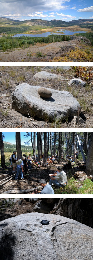
Walk out on the spillway to the edge of the lake. Look for crayfish along the edge and Western Toad tadpoles (in July) and/or young toads (after July). Walk to the right side (south) of the spillway and follow the trail that goes along the dam. At the end of the dam is what’s left of the old spillway. Look for the high water marker that shows just how deep the lake was when the dam was in full operation.Continue south along the cleared ski trail (Patterson Loop) as it winds through the thick Lodgepole forest. The trail rises up to a low rocky ridge after about 1/4 mile. This formation of welded tuff was apparently well used by the Native Americans and if you wonder along this ridge you should spot several boulders with mortar holes used for grinding food. Finding the next Native American artifact is a little tricky. You have to angle due east of the ridge to a small boulder in a clump of trees. While walking across this open area look for basalt flakes on the ground from thousands of years of Native Americans knapping stone tools in this area. Once you find the boulder, look on top for small depression called cupules that are thought to have spiritual significance for the Native Americans. This rock has been nicknamed Shaman Rock for that reason.
From the cupule rock head south for about 100 yards to a break in the lodgepoles and head west through the thick pines to the lake shore. Early in the summer this can be very wet and maybe even unpassable. Look for a couple of different wetland plants like pink Small Elephant Head and white Bog Orchids. In mid summer the ground may be alive with young Western Toads. Continue along the lake shore to the end of the lake and then head east down the meadow towards the peninsula of forest jutting out halfway down the meadow. Notice how the habitat changes from marshland thick with willow to drier grassy meadow. You want to continue to the low ridge jutting out into the meadow and then turn right through the clear area. Look closely for a smooth flat rock called a metate which was a kitchen appliance used by the Native Americans to grind food. Wind your way east onto the open ski trail for about 50 yards and then head right into the forest edge. You will see a clear track with bermed borders. This is thought to be part of the original emigrant trail used by the pioneers. Spend a while here thinking about all the emigrants that passed by on their way to the Central Valley and the coast.
Now head north out into the meadow. You will have to cross the South Yuba River which for most of the summer is just a trickle that can be easily forded. However, in early summer the water level flow can be quite high and you may have to get a little wet to get across. Once on the other side angle northwest across the meadow. In mid summer the wild flowers will be prolific. Later in the summer the grasses will be waist high. On the north edge of the meadow you will cross a straight track running east-west. This is the Dutch Flat Donner Lake Wagon Rd. which was the used to bring supplies to build the transcontinental railroad through the valley. Continue along this straight track for about a half mile. There is a large rock with five mortar holes just to the south of the road if you can find it. Head north up the faint trail with Castle Creek on your left. Castle Creek drains the entire Castle Valley watershed into the Summit Valley. A little less than a 1/4 mile you will run into Lake Van Norden Rd which was part of the original Lincoln Highway, the first transcontinental highway across the US. Walk west along the road over the Castle Creek bridge. About 200 yards down the road look for a faint path on the left side of the road. This is the trail that runs along the top of the dam and will take you back to the spillway where you will see the old control wheel for the valve that emptied the lake. You have now completed the loop of the lake
We came here on 9/13/19 and found the spillway was closed to the public and no lake in sight. It has apparently dried up.