- Distance: 13.5 miles full route, 10 miles with car shuttle
- Elevation gain: 2478 ft
- Maximum elevation: 8047 ft
- Difficulty: Difficult
- Start: Intersection of Donner Pass & Soda Springs roads
- Activities: Mountain bike, hike
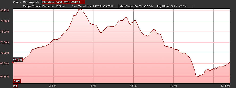
The Hole in the Ground ride is probably the best known mountain bike ride in the Donner Summit area. The trail probably offers one of the best single track rides in the Sierras. As the elevation profile below shows, this is a ride with lots of climbing and downhill stretches. The highest point of the ride is almost at the top of Andesite Peak and the views of the Donner summit area are spectacular. The best time of the year to do this ride is from late July to middle of October when the trail is dry.
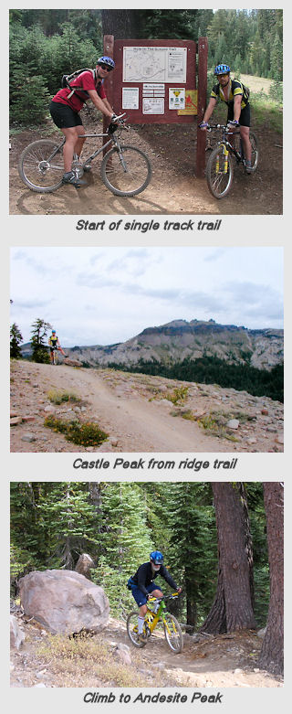
The ride can be done in either direction, but is almost exclusively done in the counter clockwise direction. The trail can be done in a single 13.5 mile loop starting at the intersection of Donner Pass and Soda Springs Roads. Alternatively, a car shuttle can be set up with a car at the Boreal offramp and another at Sherrit Lane. This will cut off about 2.5 miles from the total loop ride. This guide will describe the full loop ride. From the parking lot at the intersection of Donner Pass & Soda Springs road ride east on Donner Pass road to Bunny Hill Rd. Proceed left up the winding dirt road that goes along Hwy 80 to the Boreal ski resort parking lot. Take the underpass across Hwy 80 and proceed up the paved road on the other side to the dirt road leading to Castle Valley. Continue up the road for a little more than a half mile to the start of the single track trail up to Andesite peak. There is a sign and map on the left side of the road that marks the trailhead. Take the single track to the left. This is the most difficult climb of the ride with several switchbacks. Besides the steep climb sections, there are rocks and tree roots that can slow you down. At the top of the climb up Andesite Peak the trail heads north along the rocky ridge line climbing steadily until the top of the ridge is reached. At this point the trail splits and the ride continues to left where is dives down off the ridge in a series of rocky switchbacks. At the bottom of descent the trail winds northwest for a couple of miles through the coniferous forest. The trail is well worn from this point but is not marked with much signage. There are several stream crossings that will vary in water level depending on the time of the year. The trail proceeds over large stretches of granite boulders as it continues. At about the 10 mile point the trail passes through a low flat area. There is a natural depression here that is the Hole in the Ground. A short distance further on the single track turns into a wider logging road which proceeds for a mile or so. Keep an eye out at this point for a trail that goes down to the left of the road. This descent trail proceeds down a series of railroad tie embankments to another section of road. Finally there is a short climb up a trail that opens onto the paved Sherrit Lane. If your shuttle car is here you are done. Otherwise, turn right on the lane and pedal up to Donner Pass Rd. Go left across Hwy 80 and follow Donner Pass Rd to the starting point at Soda Springs Rd.


Thank you for posting information about Hole in the Ground trail. We rode it two weeks ago and I must say, it was one of the toughest mtn bike trails I’ve ridden. It’s far more challenging than Mr. Toads and equally as fun. I want to ride it again with a helmet cam but then again everyone can see how many times I fell!