
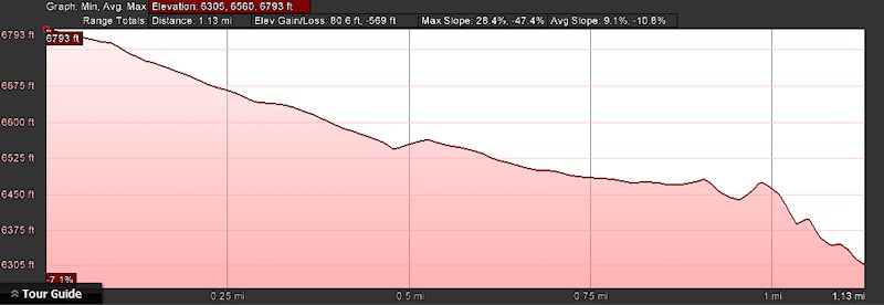
- Distance: 2.3 miles roundtrip
- Elevation gain: -506 ft
- Maximum elevation: 6739 ft
- Difficulty: Moderate (easy going down – a slog coming up)
- Start: Trailhead on Soda Springs road
- Activities: Hike
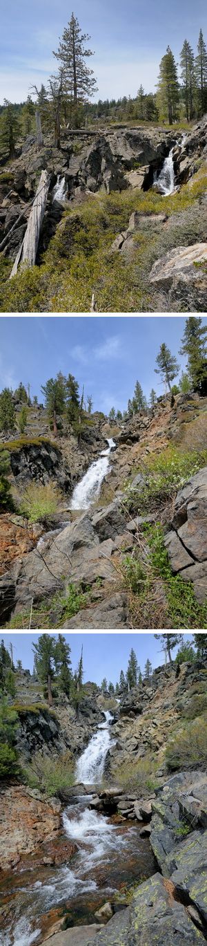
This relatively short hike is for the waterfall lovers out there. Serena Creek Falls (39 16’35.89″N, 120 23’05.40″ W) is a spectacular waterfall when the snow melt starts. The water falls approximately 150 ft down the steep cliffs of Serena Creek gorge as it heads down to the north fork of the American River. The falls flow as long as the water from Serene Lakes flows over the dam at the outlet from Serene Lakes which in a normal year is usually into the middle of June. If you’re going to see the falls in their full glory, it’s a good idea to check that the flow over the Serene Lakes dam is pretty robust before you take this walk.
The trailhead is on Soda Springs Rd about one mile down from where the the dirt road begins. There is a US Forest Service sign on the right side of the road at an old logging road where you can park and start hiking down. The rocky trail (a mixture of basalt and granite) descends into Serena Creek gorge and does a long zigzag down to creek. The trail is the remnants of that old logging road and is overgrown in several spots. The first zig is about a quarter of a mile and where is zags is pretty overgrown so it may not be obvious that the trail turns sharply to the right. The trail is exposed during the middle of the day so it’s best to do this on a cool day or in the early morning or late afternoon when the direct sun isn’t beating down on the trail. On a hot day the walk up can be a real slog. After the first zag the trail drops down into the mixed conifer forest and is much cooler. Once the trail gets to the bottom of the gorge you will hear the creek on your right. The trail follows the creek south to the top of the falls themselves.
At the top of the falls you get a great view down the gorge to its intersection with the Royal Gorge where the creek joins the American River. There is a majestic Jeffrey Pine that stands sentinel at the top of the falls and Sierra Junipers are anchored into the edges of the rock cliffs. The water polished rock at the top is slippery so be careful if you are walking near the drop off. You can get to the bottom of the falls on the the east side of the falls by descending through some thick Manzanita and down through a field of rocky scree. There is a cool pool at the bottom of the falls that can be invigorating on a warm day. After you have enjoyed the roar of the falls and the beautiful landscape cut by the white foam of cascading waters, it is time to make the long trek back up the hill and out of the gorge. The lower part of the trail is shaded by the forest, but the final stretch is pretty exposed. There is a nice log about half way up the last stretch that is a great spot to rest and have a drink.
While this trail can be done any time during the summer, it is best done in May and June while the water is flowing. The views are spectacular, but it is really the falls that make the long climb back out of the gorge worth the effort.
Elevation profile (one way)
The trail has become over grown in recent years. Even in the worst drought years the pools have always held water. Trout too.
Way back in the day me and hardy friends hiked the dry creek to The Cedars and back up the forest on the north side of the dirt road. Did it in shorts moving through manzanita. I called it the “manzanita treatment”.
Even way back then, the mid 60’s, we encountered The Cedars patrol and had a bit of verbal warfare with them.